BY LARRY COLLINS
On March 10, 2011, the tsunami-prone nation of Japan—arguably the most earthquake- and tsunami-prepared nation in the world—was the setting for an epic tsunami tragedy whose effects are still being felt today and whose reverberations will affect tsunami-prone nations for years to come.
The Japan earthquake and tsunamis killed nearly 30,000 people (far more would have died had it not been for Japan’s nationwide ultrapreparedness efforts). It was perhaps the most comprehensively documented tsunami catastrophe in history, having struck a technologically advanced nation whose state, news media, security, and private cameras were rolling throughout the event. The tsunamis decimated many of Japan’s warning systems and defenses and overran entire modern cities as the world watched in real time. Making the situation even more desperate was the tsunamis’ impact on several nuclear power plants, where the waves overtopped protective walls, flooded support facilities, and disrupted or disabled critical functions like the cooling of fuel rods. It was a double catastrophe and, as often happens in disasters, one problem seemed to compound the other—a lesson for all disaster-prone regions of the world.
It was under those conditions that the United States government offered many of its resources. Those resources included military assets to support search and rescue, road clearing, and other critical needs; nuclear experts; a wide range of advisors; and resources of the U.S. Agency for International Development (USAID), which included two “heavy”-rated urban search and rescue (USAR) teams from Virginia’s Fairfax County Fire & Rescue Department (FCFRD) and California’s Los Angeles County Fire Department (LACoFD).
This two-part series is a recap of the post-tsunami USAR operations conducted by the U.S. teams and their international colleagues and the work done by USAID, the U.S. Air Force, and other elements of the U.S. government.
JAPAN IS HIT
Japan was shaken by a 9.0 earthquake on March 10, 2011, at 2246 hours Pacific Standard Time (PST). This was less than 24 hour hours after the LACoFD “heavy”-rated international USAR team had returned from a two-week deployment to the Christchurch, New Zealand, earthquake disaster under the auspices of USAID. Striking off the Northeast coast of Honshu, it was the strongest earthquake ever recorded in Japan. The epicenter was 45 miles east of Honshu Island’s Oshikia Peninsula, 231 miles northeast of the capital city of Tokyo (which was largely destroyed by an earthquake and fire that killed 140,000 people in 1923).
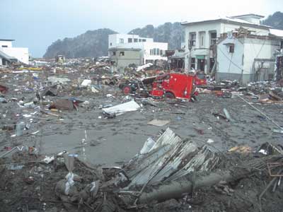 |
| (1) Kamaishi City after the 2011 tsunami, during the USAR operations. [Photos courtesy of Los Angeles County (CA) Fire Department.] |
Within minutes of the quake, the United States Geological Survey (USGS) reported that the depth of the rupture was just 15 miles—a very bad sign—because the shallower the earthquake, the more violent the shaking at the surface of the earth’s crust. A quake of that size, with the rupture occurring so close to the surface and with strong shaking lasting minutes, almost always will result in some kind of disaster if it occurs in populated areas. This was demonstrated in the devastation that occurred in Haiti in January 2010. In addition, the Japan quake occurred offshore, meaning that damaging tsunamis were likely and would be striking the closest coastal areas in minutes.
Many firefighters and USAR team members across the United States monitor earthquakes in relation to their role on the teams. They received automatic notifications from the USGS on their cell phones, e-mail, or pagers (anyone can sign up for the autonotification for quakes at www.usgs.gov). So, their situational awareness was at a heightened level early in this event, something that became important for the USAR teams that were to be dispatched to assist in Japan.
In one example of the interconnectivity between science and first responders to improve situational awareness that has been achieved in recent years, within minutes of the quake, I received a text message from USGS lead scientist Dr. Lucy Jones indicating that seismological instrumentation detected dozens of feet of surface displacement near the epicenter. This was a strong indication that a major disaster had just occurred and that large tsunamis may have been generated. The implication was that the coast of Japan might already be under attack from waves and that a tsunami event may soon impact the entire Pacific Rim. The message, along with the USGS quake alerts, followed by live television images of the Japan coastline being hit by huge tsunamis, started a notification tree that, late on a Friday night, had off-duty and on-duty personnel preparing for possible disaster response.
Back in Japan, the quake, since identified as the Higashi Nihon Daishinsai (Eastern Japan Great Earthquake Disaster), was immediately followed by Tsunami Warnings issued by Japan officials for the Northeast coast of Honshu Island, which had been shaken for nearly 2½ minutes. Local tsunami warning systems, including strategically placed warning sirens, were activated along the entire Northeastern Japan coastline. Minutes later, a series of devastating tsunamis, some up to 125 feet high in some places, began decimating Japan’s coastal cities as the world watched live television coverage of the unfolding calamity.
As this information was being absorbed by personnel who might be sent to Japan, there was the other immediate problem of potential tsunami impact along the West Coast of the United States. A series of tsunami watches and warnings was already being issued by the Hawaii and West Coast/Alaska Tsunami Warning Centers for a possible series of tsunami impacts on the Hawaiian Islands and the Pacific mainland coast as the waves spread across the Pacific at the speed of a jet aircraft. Tsunami watches and warnings were initially issued for at least 20 other nations. At first, California was placed under a Tsunami Watch (possibility of a tsunami; make appropriate preparations), which shortly thereafter was upgraded to a Tsunami Warning, indicating that strategically positioned ocean buoys had confirmed a series of tsunami waves shooting across the Pacific and that there would be an actual impact in Southern California at about 0830 hours PST.
AMERICAN ASSISTANCE OFFERED AND ACCEPTED
In Washington, D.C., State Department and USAID officials were fully engaged in the effort to assist Japan in this rapidly evolving disaster. Within hours of the quake, U.S. Ambassador to Japan John V. Roos declared that the Japan disaster met the requirements for U.S. offers of assistance. Japan’s government accepted the offer of assistance in the form of various forms of technical expertise, USAR teams, and other help. Immediately, USAID’s Office of Foreign Disaster Assistance (OFDA) provided an initial $100,000 through the U.S. Embassy in Tokyo to assist with local relief efforts (a standard beginning of U.S. assistance to disaster-stricken nations) and then began activating other American government assets.
USAID immediately activated a Response Management Team (RMT) at headquarters in Washington, D.C., and deployed a Disaster Assistance Response Team (DART) to help coordinate U.S. assistance operations on the ground in Japan. As part of that response, USAID activated the USAR teams from Fairfax County (identified for international response as USA Team 1 or USA-1) and Los Angeles County (USA-2) in the 74-person “heavy” USAR Team configuration. Both USAR task forces were directed to report to Dewey Perks, the DART operations coordinator (and retired battalion chief of the FCFRD, who was a leader of Virginia Task Force 1/USA-1 and a member with decades of experience responding to major disasters).
USA-1 (Fairfax County) and the DART were readied to board aircraft on the East Coast, rendezvous with USA-2 at Los Angeles International Airport, and proceed to Japan from there. Meanwhile, the equipment caches of both teams would be transported by military cargo planes accompanied by logistics specialists from the teams.
The Fairfax team mobilized its members and the L.A. County team activated its mobilization plan for the second time in two weeks while the West Coast states, Hawaii, and the U.S. government prepared for possible disaster-level tsunami impacts at home.
PREPARATIONS FOR LOCAL TSUNAMI IMPACT
One of the common traits of tsunami disasters is their ability to affect many nations at the same time (and the direct effects can continue for hours or even more than a day later). The Japan tsunami affected the entire Pacific Rim. One example of this was the dual deployment of resources by the LACoFD.
Simultaneously, as the scope of the catastrophe along the East Coast of Japan was becoming more clear (and while mobilization plans for both American international USAR teams responding to Japan were activated), back home in the United States, fire departments, law enforcement agencies, lifeguard departments, local and state offices of emergency services, and other organizations were preparing for the potential for tsunamis to strike Hawaii and the West Coast of the United States in a matter of hours. Their actions were largely based on the alerts being issued by the Tsunami Warning Centers based in Hawaii and Alaska.
 |
| (2) The LACoFD Command and Control Center, where the Department Operations Center was staffed while monitoring the potential for the tsunamis to strike Hawaii and the U.S. West Coast. |
In some places, coastal evacuations were being ordered based on the Tsunami Warnings. In other places that had been placed under Tsunami Watch, the public was being alerted, and contingencies were being developed for possible coastal evacuations if the Watch was upgraded to a Warning.
The response to a teletsunami event can be somewhat complex, involving a decision tree that ties hundreds of local, regional, state, and federal agencies and departments together in what should be a rather unified approach in each region. In this process, every state, region, county, and city has its own unique set of circumstances and challenges that must be recognized, understood, and addressed to ensure lives are protected. The worst thing would be to have people in harm’s way who could have been forewarned and evacuated before the tsunamis struck. This is especially true of near-source events (where the tsunamis may strike shore in minutes, as they did in Japan). But there is also potential danger in evacuating millions of people in a matter of hours for a possible teletsunami event, if evidence like the tsunami buoy system and actual eyewitness accounts of the level of impact in other areas indicate that actual damaging or life-threatening tsunami waves aren’t likely to materialize.
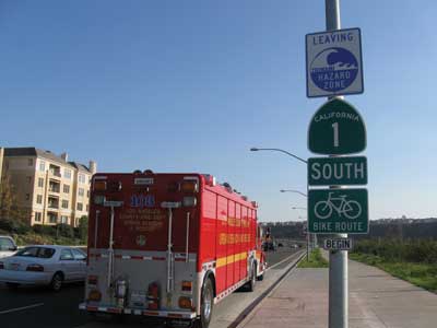 |
| (3) The signage at the border of the designated tsunami inundation zone along the Los Angeles County coastline, in accordance with the Tsunami Plan. |
So for the decision makers of all the coastal entities, there is a constant balance between maintaining awareness in real time of the indicators of a tsunami event that may be occurring and the warning of coastal residents and possible evacuation of coastal zones. When in doubt, erring on the side of caution (i.e., evacuating the coast) is usually advisable to avoid being caught by surprise by a “sneaker” tsunami event. In some cases, however, the right decision lies somewhere between simply alerting coastal residents and conducting a full-scale evacuation. That’s what was happening along much of the U.S. West Coast, where officials were watching the effects of the tsunamis’ pulses on the Hawaiian Islands and then the first areas of the U.S. mainland that were being impacted.
The state of Hawaii wisely conducted wide-scale evacuations in anticipation of the tsunami. In fact, some of Hawaii’s beaches and coastal zones did experience significant movement of the ocean, which caused serious damage to some resorts and occupancies.
Meanwhile, on the continental United States, as some Tsunami Watches were upgraded to Warnings, authorities alerted coastal residents and visitors and, in some cases, ordered evacuation of vulnerable coastal zones.
In Los Angeles County, a nuanced approach was taken, based on evidence from the northern areas of the U.S. West Coast indicating that the event was more likely to take the forms of a “rapid tidal surge” rather than actual formed tsunami waves. The L.A. County Emergency Operations Center (EOC) was activated, along with the EOCs of the various coastal cities including Los Angeles. Department Operations Centers (DOCs) of various fire and law enforcement agencies with coastal jurisdiction were also activated. The Red Cross and other civilian organizations with responsibility for supporting the tsunami warning/evacuation system also geared up for possible action. The L.A. County Lifeguards, a division of the LACoFD, were integrally involved in this process, including maintaining contact with the USCG and lifeguard agencies in Hawaii and parts of the mainland that would be impacted first.
At the LACoFD’s DOC and headquarters in East Los Angeles, plans were being made for the simultaneous activation of USA-2 to join USA-1 in conducting search and rescue operations in Japan under the auspices of USAID and plans for a potentially damaging series of tsunami impacts on the coast of Southern California. Starting just after midnight (PST), Chief Deputy John Tripp led the process, which included a continuing assessment of the anticipated impact and time (about 8:30 a.m. PST) based on a continuing stream of information from the Tsunami Warning Centers and other sources.
Throughout the night, an even greater response capability was organized as well as a coordinated plan for notifying the public, notifying the news media, and keeping people out of harm’s way. These contingencies included the potential response of USAR companies, swift water rescue teams, fire boats, lifeguard units, firefighting units, EMS units, hazmat task forces, helicopters, heavy equipment, and other resources if the coast was hit hard. Also discussed was the possible need for one or more California regional USAR task forces for the coastal area if the tsunami event materialized as a more damaging event than was being projected by the Tsunami Warning Centers and other authorities.
Tripp coordinated the operations and plans with LACoFD Deputy Chief Mark Bennett, whose Central Regional Operations Bureau includes the coastal zones of L.A. County (and Catalina Island, 26 miles from the mainland) and the Lifeguard Division of the department. The Central Operations Bureau was tasked with preparing a full-scale incident action plan (IAP) for this event, with more specific plans for local tsunami impact based on direction and recommendations from Tripp and the DOC.
An incident, designated as “Coast Incident,” was initiated. An IAP was established for fire department operations that included movement of fire department and lifeguard vessels to the safety of deep water; warning residents and visitors to stay away from the beaches; contingencies for moving land-based fire department and lifeguard resources to high ground/safe zones; staffing and staging specialized resources in high ground/safe zones; assisting law enforcement with evacuations if they became necessary; and a post-impact search and rescue plan that included land-based, boat-based, and helicopter-based rescue assets, casualty treatment and transportation, disposition of the dead, firefighting- and conflagration-fighting operations, and so on.
Because the USAR teams are staffed three deep in each position with two full equipment caches, the LACoFD is capable of deploying multiple task forces simultaneously, if necessary, under unusual circumstances. So, while USA-2 was gearing up for deployment to Japan, the department’s Technical Operations Section prepared for the possibility of local, regional, state, and federal USAR deployment if other parts of the U.S. West Coast were hard hit by the tsunamis heading toward the United States.
In the early morning hours, as information from the Pacific-based National Oceanic and Atmospheric Administration tsunami buoys and impact on distant coasts began indicating that Los Angeles County could expect a series of “serious tidal surges” instead of more damaging “formed” tsunami waves that might rush inland and carry people away, the decision was made to warn people to leave the beaches, deploy emergency watercraft into deep water, establish lookouts, patrol the coast, maintain local resources in a ready state, and prepare for the effects of strong tidal surges (which occurred in the morning and lasted throughout the day in Southern California), causing extensive damage to L.A. County marinas.
A full-scale evacuation was not initiated in Los Angeles County because a growing body of information coming from multiple sources didn’t indicate the kind of tsunami impact that would require evacuating the coastal zones. Harbors and marinas, naturally, were considered at higher risk for damage because quickly rising and lowering water levels would cause currents and other effects that were difficult to predict with certainty. Businesses and residents in the marinas and harbors were notified to take appropriate precautions (including securing vessels and moving them to deep water).
The impacts of the tsunami began showing up around 8:30 a.m., causing serious damage in some areas, close calls in other areas, and at least one fatality in Northern California.
RESPONSE TO JAPAN
Meanwhile, as the LACoFD and other coastal agencies in the United States addressed the local tsunami impacts, preparations for mobilization of USA-2/LACoFD’s USAR team continued throughout the day. USA-1 (Fairfax) and the DART were en route to Los Angeles from the East Coast. The USA-2 Logistics personnel successfully deployed a full International Heavy USAR team equipment cache to March Air Force Base, where it was loaded onto a cargo plane and took off for Japan with the USA-2 logistics personnel aboard. Soon thereafter, USA-2 departed for Los Angeles Airport at 0130 hours on March 12, meeting USA-1 and the DART there at 0215 hours. After refueling, a crew change, and loading, USA-1 and USA-2 were “wheels up” and heading toward Japan.
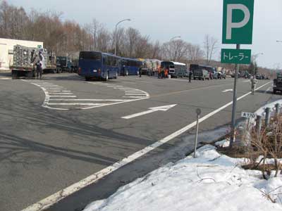 |
| (4) The convoy had to cross high-mountain passes to reach the coast, a five-hour ride using the ground vehicles supplied by the Misawa Air Force Base. |
After a refueling stopover in Anchorage, Alaska, both teams landed at Misawa Air Force Base (in Northern Japan) at 1520 hours (Japan time) on March 13 and were processed through Japan Customs at approximately 1630 hours Japan time. There, DART members and USA-2 and USA-1 leaders met with the base commander and interpreters provided by the Japanese Ministry of Foreign Affairs.
The United Kingdom’s USAR team also landed at Misawa; the UK and the USA-1 and USA-2 teams were assigned to travel together, establish a base of operations, and operate jointly in a sort of unified command. All three teams would work together, sometimes with different assigned search areas based on the needs of Japan’s local command.
A Brief History of the Quake Zone
The Japan quake and tsunami catastrophe caused a massive rupture zone about 60 kilometers (km) off the coast. It resulted in 5 to 8 meters (m) (15 to 24 feet) of upthrust on a section of the seabed measuring 180 km wide. The massive displacement of ocean floor generated a series of tsunami waves exceeding 10 m (30 feet) in height along much of the Northeastern coast, which penetrated up to 10 km (6 miles) inland in some places. In certain places (the results of which USAR team members were to witness for themselves), the tsunamis were much higher than 30 feet. In fact, 30-foot tsunamis would have been dwarfed by the monster tsunamis that struck the port city of Ofunatu.
Ofunatu is situated on a long, wide coastal inlet that opens to the sea by way of a narrow entrance sandwiched between two high headlands. Prior to the tsunamis, factories, heavy industry, and commercial zones had been along the bottomlands, nearly level with the sea. The hillsides rising away from the water had been covered densely by homes and light commercial zones. Anyone familiar with hydrodynamics can look at the coast there and predict that tsunamis approaching Ofunatu will create a sort of venturi effect that compresses and raises the waves when it comes into the inlet.
And that’s exactly what happened: As the tsunamis were squeezed between the headlands, they rose precipitously to a height measure and were verified by scientists at 124 feet above sea level. After squeezing past the narrows, the tsunamis encountered a widening of the bay, which eventually transitions to a long river valley leading into the coastal mountains. The waves spread out and rolled across the entire bay and much of the valley in which it lies.
Based on physical evidence (including fishing gear and other flotsam scattered high above the bay) found along the headlands, a joint research team from Yokohama National University and the University of Tokyo initially estimated that at least one tsunami wave exceeded 30 m (90 feet) in height. More recently, a University of Tokyo researcher named Taro Iwate has studied the land and estimated the tsunami height in Ofunato was 37.9 m (124 feet). This height is based on scour lines and other physical evidence he found on the slope of a mountain some 200 m (660 feet) away from the coastline. That matches descriptions of some local residents/survivors we encountered, who described huge waves “the size of a 10-story building” arriving just 13 minutes after the earthquake.
There is historical evidence of the veracity of those early reports from local residents who witnessed the event and lived to tell about it. Long before the March 2011 catastrophe, scientists had determined that Ofunato’s bay had been struck by a tsunami 125 feet high generated by the Meiji-Sanriku earthquake in 1896, and in 1933 large sections of the city were destroyed by a 96-foot-high tsunami. So, Ofunato was a known hot spot for devastating tsunamis that largely destroyed the city at least two times in the known past.
Endnotes
1. This increasingly effective “bridge” between science and emergency response is an example of the collaboration that’s been happening for many years among scientists, engineers, and progressive emergency responders in some areas of the United States. These partnerships have yielded incredible benefits for all the disciplines, which have learned from each other about aspects of disaster planning, preparation, education, response, and post-disaster study and the implementation of lessons that otherwise likely would not have happened. And it has opened new doors to funding, intelligence gathering, and sharing as well as kept each of the disciplines closer to the cutting edge than would otherwise be possible.
2. “Heavy” USAR Team is an international rating roughly equivalent to the U.S. Type I USAR Task Force, with certain key differences and options related to international needs and operations.
LARRY COLLINS is a battalion chief and 31-year veteran of the Los Angeles County Fire Department (LACoFD). He was a captain of Rescue/USAR Task Force 103 for 20 years, responding to technical rescues and multialarm fires across Los Angeles County. He is a leader of the LACoFD’s FEMA/USAID USAR task force for domestic and international response and serves on FEMA’s national USAR Incident Support Teams. He is the author of dozens of research articles and the textbook series Technical Rescue Operations; the Rescue chapter of The Fire Chiefs Handbook, and the Support of Rescue Operations chapter of Fire Engineering’s Handbook for Firefighter I and II.

