
By Eric G. Bachman
Lac Megantic, Quebec, was not a well-known location to Lancaster, Pennsylvania, emergency managers before the devastating July 6, 2013, train derailment that killed 47 citizens, destroyed several downtown blocks, and changed that city’s landscape forever. Soon after, numerous other locales both well-known and unknown were in the spotlight because of train derailments involving crude oil or ethanol. Countrywide, interest in rail and crude oil safety was heightened and emergency preparedness officials were pressed for mitigation answers for the high-hazard flammable liquid train (HHFT) scenario.
The media and politicians in Lancaster County were no different from those in other areas around the country as they queried local emergency response agencies and municipal officials as well as the Lancaster County Emergency Management Agency (LEMA) about the level of derailment preparedness. It is important to recognize that Pennsylvania is a commonwealth that yields layers of government. Lancaster County has a population of more than 520,000 and is made up of 60 separately governed municipalities. There is no countywide fire department, and the county is protected by 70 independent fire companies. One is career, one is combination, and the remainder are all-volunteer. It is also important to consider that preparedness is a broad concept influenced by many factors including perspective of local hazards, past experiences, and training. So, the responses from several agencies varied.
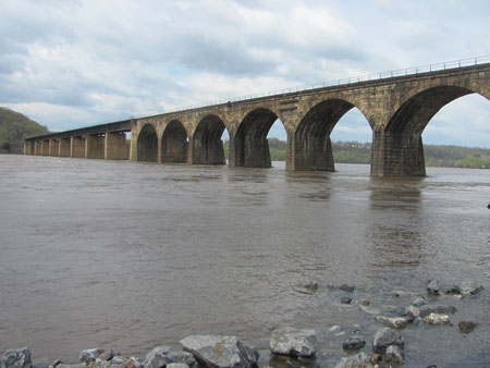 |
| (1) Crude oil unit trains travel over the rail bridge spanning the Susquehanna River from York County (background) to Lancaster County (foreground). (Photos by author.) |
Resources
Lac Megantic; Aliceville, Alabama (November 2013); and other host locations to crude oil derailments were cause for LEMA to evaluate its railroad preparedness. It was quickly realized that what was in place compared to the now-historic case-study scenarios was insufficient. Thus, began the task of improving preparedness. Early in 2014, LEMA researched rail incident planning resources and sought guidance from the Pennsylvania Emergency Management Agency (PEMA). The available resources were generic and virtually nonexistent.
Plan Development
Essentially starting from scratch and an outline of the problem, we arrived at a starting point. After reviewing the outline, we quickly realized that a basic planning template was already in place. Title III [Emergency Planning and Community Right-To-Know Act (EPCRA)] Section 303 of the Superfund Amendment Reauthorization Act (SARA) of 1986 prescribes the development of an off-site emergency response plan (OSERP) for facilities that use, store, or manufacture extremely hazardous substances (EHS) at or above a threshold planning quantity (TPQ). The purpose of OSERPs (see my article “Off-Site Emergency Response Plans: A Preparedness Tool,” Fire Engineering, November 2011) is to identify locations that use, store, or manufacture hazardous materials within a community; determine public exposures; and develop response processes and public protective action mechanisms.
As the hazardous materials administrator for LEMA, my job is to develop and maintain OSERPs for the 192 fixed facilities in the county that maintain EHS at or above the TPQ.
By comparison, OSERPs are intended for fixed facilities, not transportation incidents—like apples and oranges. What does a cold storage warehouse that uses anhydrous ammonia have in common with a rail line that transports crude oil? From a planning perspective, it is just semantics.
 |
| (2) The rail line travels through this town of 2,700 people. |
Like a four-walled structure (cold storage warehouse), the rail line has a specific footprint. Second, the hazard is known. For the warehouse, it is anhydrous ammonia; for the rail, it is crude oil. Although crude oil is not deemed an EHS, it nonetheless can cause significant harm. For both commodities, protective action distance guidance resources are available.
For anhydrous ammonia, resources include Environmental Protection Agency (EPA) Risk Management Planning data matrixes. For crude oil, Guide 128 of the Emergency Response Guidebook (ERG) recommends an initial public protective action distance of 0.5 mile. So as dissimilar as the two examples initially seem, from a fundamental planning aspect, there are shared commonalities.
A major component of the OSERP is outlining the roles and responsibilities of the stakeholders, including emergency services, the “facility,” and other support elements. By comparison, the OSERP stakeholder list is similar to that that likely would be involved at a train derailment.
The OSERP became the foundation template for LEMA’s crude oil plan. After subtracting building-specific elements, adding transportation nomenclature, and refining stakeholder roles and responsibilities, the self-titled “Crude Oil Unit Train” (COUT) plan was born.
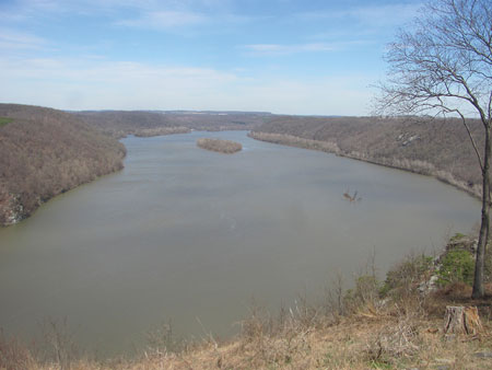 |
| (3) The recreational overlook of the Susquehanna River. The rail line parallels the river (bottom of the hill on the right). |
Frequency
In May 2014, the U.S. Department of Transportation (DOT) posted an emergency order for Class 1 railroads to notify State Emergency Response Commissions (SERCs) on the weekly transit frequency of crude oil unit trains. The SERCs, in turn, would advise affected counties. Initially, these data were treated as classified, and the local rail service stipulated that county EMA directors sign a confidentiality form to not disclose this information, not even to the local first-response community. After much pushback, this practice was relaxed. This is now available to the public.
As a result of the May 2014 emergency order, Lancaster County learned the frequency of crude oil unit trains was 10 to 16 shipments weekly. Since then, that figure has been adjusted to up to 10 shipments per week.
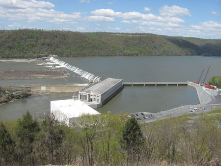 |
| (4) A view of a hydroelectric plant and dam. |
Disposition
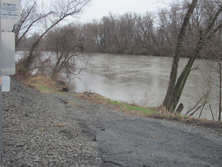
Crude oil transit through Lancaster County is destined for refineries in Philadelphia and Delaware. The crude oil unit trains enter Lancaster County from two northwestern points. One is through the rail line with land bordering Dauphin County. The other is from York County across a rail bridge that spans the milewide Susquehanna River (photo 1). The designated rail line through Lancaster County spans more than 32 miles and parallels the Susquehanna River the entire length of the county.1 It travels through 10 municipalities of wide-ranging dispositions from populated towns (photo 2) to forested rural areas (photo 3).
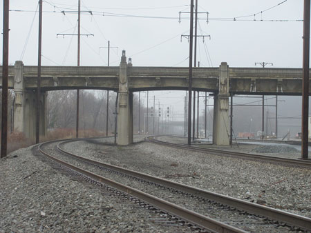
The Susquehanna River is as wide as one mile in some areas and separates Pennsylvania’s Lancaster County from York County. It travels south into Cecil and Harford counties in Maryland and ultimately into the Chesapeake Bay. The river is a heavily used and relied-on venue. Several public water suppliers maintain intakes along the river. Boaters and fishermen use the river recreationally, and several islands are used for seasonal residence and other activities. There are also three hydroelectric plants that use the river flow to support electric-generating turbines (photo 4). In addition to these facilities, the rail line passes under three large and heavily traveled intercounty vehicle bridge spans (photo 5).
Access to the river is challenging because of many locations with steep forested areas, sheer rock faces, and cliffs that span many environmentally sensitive areas. Environmental venues and habitats could be affected including a state park (photo 6), several nature preserves, as well as bald eagle and osprey nests.
 |
| (5) The rail line travels under three intercounty bridges. Two can be seen in this photo. |
Crude by Rail
Shortly after the DOT emergency order was enacted, the railroads sponsored public safety staff from affected communities to attend the 24-hour Crude by Rail training program at the Special Emergency Response Training Center (SERTC) in Pueblo, Colorado. I attended the program in July 2014. The subject matter expertise was tremendous, and the training was beneficial in supporting and expanding the COUT plan. On my return, the COUT plan was enhanced with the information learned and provided.
A Life of Its Own
Developing the COUT plan consumed almost all of the weekly activities continuously for several months. The adage “you don’t know what you don’t know” certainly applied. The anticipated issues that could arise (from a review of past incidents like Lac Megantic and evaluating against local elements) grew. It was a catalyst to delve into numerous preparedness activities that are applicable to other scenarios. For example, a list of six public boat access points along the river was developed and published by the Pennsylvania Boat Commission. Part of the planning process was physically surveying the “lay of the land” from the northwestern county line to the south county/state line. Numerous additional sites were identified, and the list grew exponentially. Not all boat access points are the same. Accessibility to and at several sites is challenging. Unmaintained roads, width restrictions, and some with height restrictions were identified. Depending on the transport vehicle for boats and other special resources, access could be prohibitive.
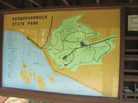 |
| (6) This map of the Susquehannock State Park shows the proximity to the river and railroad as well as several nearby islands. |
A result of the boat access survey process was the development of a robust River Access Profile Manual. This 58-page document profiles each of the 24 identified sites and describes each access path and other site characteristics. This document can be used to support the COUT plan as well as be used as a standalone document for use with other plans and river scenarios.
Public Safety
Like plume modeling for an ammonia release from the cold storage warehouse, an initial protective action distance of 0.5 miles for crude oil was recommended in the Crude by Rail training and consistent with ERG 128. Using geographical information system (GIS) data and mapping, a half-mile polygon along both sides of the rail line was created for each municipality. Potential resident population exposures were calculated for planning purposes. Special-needs facilities (schools, day care centers, nursing homes, and hospitals) were identified and individually listed with addresses and contact information in each municipal profile.
Each of the 10 affected municipalities has its own exhibit. Municipal exhibits provide the rail line disposition, identifying mile markers that are a part of the county emergency communication (911) dispatch center. Each municipal exhibit lists the first-due emergency services with their nonemergency contact information for preincident preparedness coordination. Additionally, the names, titles, and contact information for the local elected officials are included. A list of municipal public works resources such as dump trucks, back hoes, and other earth-moving vehicles and special equipment is provided. If applicable, other municipal-specific data such as storm-water and street drain (photo 7) conduit locations are included to support protective measures for spills.
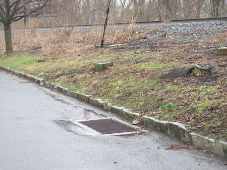 |
| (7) The storm drain by the rail line empties directly into the Susquehanna River. |
More of a “Toolbox”
Although called a plan, COUT is more an incident support toolbox that provides more resource elements than incident mitigation directions. It is separated into three areas: sections, exhibits, and attachments. Sections are administrative elements that describe the situation, authority, purpose, and scope. Thirteen incident stakeholder positions are listed in the sections area and represent the most common incident response and support positions including fire, emergency medical, and law enforcement. Other positions include the local emergency coordinator, railroad representative, county elected officials, mass care representative (for sheltering consideration), school services (for and modifying school bus routes if school is in session), and GIS staff for real-time incident specific mapping.
Exhibits
Exhibits are municipal profiles, resource lists, and procedural descriptors for acquiring special resources and unmet needs. There are 31 exhibits. Exhibits 1-3 include the ERG protective action guide, a safety data sheet for Bakken crude oil, and a corridor profile overview. Next are municipal-specific overviews that can be used separately for a small-scale incident or collectively for sharing of resources. Each municipal profile exhibit identifies at-risk populations and facilities, local emergency agencies, and municipal contacts and resources.
Following the municipal data are strategy-supporting exhibits, including water user contact information (such as public water intake companies), a list of river boom resources, and the River Access Profile Manual. A comprehensive list of boats throughout the region is included. This resource list will be further refined in the future to include specific capability typing.
 |
| (8) A draft site sign near the river drafting point. |
Because the rail line spans urban and rural areas, water infrastructure is not consistent throughout the entire span of the rail line. And because of remote access locations, water delivery for certain fire protection strategies will be very challenging. Exhibits are provided to support specific water-delivery methods for fire protection. Beyond municipal water systems, a list of static water sources is included with location, type, drafting methodology, and capacity (photos 8, 9). Also included is a mobile water tanker (tender) list with unit specifications for calculating shuttle delivery capabilities. Dump and fill times, along with other unit-specific details, are noted. Foam resources in Lancaster County and within an eight-county region are provided to gauge potential foam application strategies.
Other exhibits are resource specific. The medical resources exhibit has three subcategories including prehospital resources; aviation transport districts; and hospitals that denote trauma center level, burn center capability, and if helipad equipped. Also described are the tiered Lancaster County Mass Casualty Incident (MCI) level designations and associated automatic resources dispatched. This is useful for ordering more appropriate incident medical resources.
The white elephant in the room for this corridor is its travel along the remote land and river line edge (photo 10). An aviation resource exhibit is included and organized into three subcategories: aerial recon, rescue, and fire protection. Aviation resources that can aid in spill recon are provided to assist with determining the incident footprint:
- Aviation resources capable of fire protection are needed not to engage in air drops on burning railcars but because the rail-wildland interface fire potential is great. Aviation resources for inhibiting fire spread in the wildland areas may be necessary. Special procedures to order aviation resources are included in the exhibit.
- Aviation resources capable of rescue (hoist basket) are provided. There is potential for residents and visitors on the river and islands, as well as employees at the hydroelectric plants, to become stranded.
- Aviation rescue contingencies are important.
In addition to the resident population profile, special environmental venues (nature preserves and state parks) inclusive of trail maps to support locating and evacuating hikers are listed. Where available, maps of the known trails in each nature area are included. A cleanup contractor list is also provided but only for informational purposes, as the responsible party would engage in contracting commercial cleanup contractors.
Special procedural documents are provided in other exhibits to support expanding incident situations. A fill-in-the-blank declaration of disaster emergency (for elected official use) is provided. When endorsed, it allows local agencies to obtain life-safety resources outside of typical (time-consuming) procurement procedures. Additionally, a state-level resource request form for ordering unmet needs as well as the criteria for completing and submitting the document are provided.
Attachments
The attachments are for other incident support. Included are incident command system forms to support developing the incident action plan. Other references, including the “U.S. Coast Guard River Booming Guide,” the “American Association of Railroads Tank Car Identification Guide,” and other general guidance documents are provided.
 |
| (9) A draft site on the river side of the rail tracks. |
Distribution
The Local Emergency Planning Committee (LEPC) of Lancaster County reviewed and approved the initial COUT Plan in October 2014. Copies were distributed to the immediate stakeholders. Many modifications were made, and an update was published in April 2015. After significant enhancements, such as the medical and aviation resource exhibits, the latest copy was published in August 2015. The COUT Plan distribution list identifies 50 stakeholder agencies.
In addition to local fire, emergency medical, and law enforcement agencies, the plan has been sent to each bordering and regional task force county EMA, the American Red Cross (for establishing shelters), each of the four county hospitals, the five regional state-certified hazmat teams, PEMA, the Pennsylvania Department of Environmental Protection, the Pennsylvania Office of the State Fire Commissioner, the Maryland State Police, the Maryland Department of the Environment, and the U.S. Environmental Protection Agency.
LEMA received great interest and requests from agencies outside of the region and state for a copy of the plan. The plan has been widely distributed to emergency preparedness agencies.
 |
| (10) Accessibility to the rail line is challenging because of the natural terrain. |
Outreach
The COUT plan is a tool; and, like any tool, users need to be trained on it. LEMA developed a training program that is delivered locally. The program reviews the plan’s capabilities and limitations and the sections, exhibits, and attachments. Customized review and tabletop discussion are provided using the local exhibits and a review of special processes and procedures.
Emergency Planning Keys
There are several keys in emergency planning. One is understanding the problem and identifying capabilities and limitations. If you don’t know the issue or what can and cannot be supported, failure is imminent. A second factor is study. Study incident case studies and correlate the scenario, actions, results, and lessons learned locally. A third key is details. Sometimes, the little things like resource ordering procedures become big issues and create significant setbacks. Before an incident is the time to identify and resolve potential problems.
Every incident starts and ends locally. Since Pennsylvania is a commonwealth, emergency planning rests with local officials. LEMA did not develop the COUT plan to “tell’” local officials how to do their job. It is a tool in the toolbox to support their operations with local and regional resources, specific organizational procedures, and other considerations that they may not be aware of or have little time to assess before an incident. Whether or not the COUT plan is an effective document remains to be seen. It is hoped that it never has to be used. But an often referenced axiom is, “Failing to plan is planning to fail.” There is no perfect plan. There are just too many variables, especially for a 32-mile-long “facility.” But, reducing the unknowns beforehand is invaluable.
Endnote
1. A map of the rail line flowing along the Susquehanna River is at the Pennsylvania Emergency Management Agency Web site: http://www.pema.pa.gov/Documents/1/12-2-2014%20PA%20Lancaster-Royalton-penciled.pdf.
ERIC G. BACHMAN, CFPS, is a 34-year veteran of the fire service and a former chief of the Eden Volunteer Fire/Rescue Department in Lancaster County, Pennsylvania. He is the hazardous materials administrator for the County of Lancaster Emergency Management Agency and serves on the Local Emergency Planning Committee of Lancaster County. He is registered with the National Board on Fire Service Professional Qualifications as a fire officer IV, fire instructor III, hazardous materials technician, and hazardous materials incident commander. He has an associate degree in fire science and earned professional certification in emergency management through the state of Pennsylvania. He is also an assistant chief with the West Hempfield (PA) Fire & Rescue Company.
Hazmat: Q & A: Robert Lipscomb on the Lynchburg (VA) Oil Train Derailment
Hazmat and Industrial Firefighting: Fracking and the Fire Service
Incident Command and Fireground Management: Core Command Competencies
Fire Engineering Archives

