A release from ESRI
The Wilson (NC) Fire/Rescue Services (WF/RS) organization is as impressive as it is diverse. From response time analysis to building inspections to modeling natural disasters, WF/RS uses GIS as a high-tech firefighting weapon that protects both citizens and responders.
Emergency planning for hurricanes, floods, and other natural disasters begins with GIS-based maps and information acquired from multiple sources. When a major incident occurs, WF/RS has the information needed, such as a 100-year flood plan model and shelter locations, to plan a response, evacuate people, and maintain situational awareness as the event unfolds.

(1) The mobile data computers in fire apparatus give the company officer all types of data to view remotely.
Geospatial analysis allows WF/RS to accurately evaluate performance and ensure that it is meeting established goals. Maps of incidents—response times, arson, traffic accidents, building fires, and false alarms—can be generated by week, month, and quarter. WF/RS senior staff can identify if there are incident spikes that may require public education or further investigation.
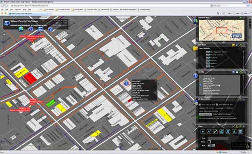
As part of the strategic planning process, WF/RS has a GIS-based executive dashboard that brings multiple tabular and geospatial files together into a single, comprehensive view. It’s available to fire commanders to track patterns, identify trends, or allocate resources. Recent events, such as building inspections, emergency medical calls, and fire responses, are viewable in the form of reports, maps, and charts. The application is available via a simple Web browser. Customized analysis routines ensure data updates automatically so that the information presented is always current.
For tactical, daily use, mobile data terminals in fire trucks provide valuable information for firefighters. Street maps of the city show the location of the incident. Digital preplans help firefighters view floor plans, digital images, special tactical considerations, exposures, water supply, utilities, and more. This allows personnel to quickly ascertain critical information for safer incident response.
(2) Agencies like Wilson Fire/Rescue Services are adopting the U.S. National Grid to dramatically improve multiagency interoperability.
In addition, the City of Wilson has built an emergency response common operating picture (COP) using the ArcGIS API for Flex. This will provide WF/RS with real-time data feeds and analysis during large-scale incidents. As part of the COP, the city and county are supporting the use of the U.S. National Grid (USNG), which provides a common set of georeferenced points that are uniform across the country. As more local and state agencies adopt USNG, the common grid will improve interoperability when a major, multijurisdictional disaster occurs.
“We’ve been using GIS for years,” says Wilson’s fire chief, Don Oliver. “With any emergency, you have just minutes after the alarm is received and arrival on scene. Accurate information about the incident is beneficial. GIS gives us insight into the situation before we arrive.”
To learn more about how GIS is used in the fire services, visit esri.com/fire.