A release from ESRI
The Baltimore City (MD) Fire Department has seen its share of challenges. Staff reductions, station closures, and spending cuts have hit this agency as well as many others across the country.
To better manage through tough economic times, Baltimore Fire has begun to rely more on technology to optimize the deployment of limited resources and effectively provide fire and rescue services.
Over the last two years, the department implemented a robust ArcGIS platform with a number of successful applications that support complex mission demands.
Jim Potteiger, special assistant to the chief of Baltimore City Fire Department, and Peter Hanna, a firefighter/paramedic, lead the charge to implement GIS within the department.
The result is a leading-edge GIS that grew out of the work of two firefighters with no prior software experience, training, or official budget.
Getting Response Times Right
The Baltimore City Fire Department serves a geographic area of 81 square miles and a population of more than 640,000 residents. Led by fire chief James Clack, the agency has more than 1,800 members, who are divided into two management branches—Emergency Operations and Planning and Administration. Every year, the department responds to more than 163,000 emergency 911 calls.
(1) GIS supplies an intuitive method to view each battalion and fire station. Staff can then drill down to access other information.
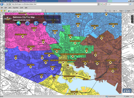
(2) Looking at the location of fire companies allows Baltimore Fire to accurately assess coverage based on different criteria. In this map, areas in green show adequate response times. Areas in orange show insufficient response times.
Prior to the use of GIS, the department found that meeting its response time standards and guidelines was difficult, given the number of calls it receives.
The agency wanted a more efficient method for determining whether it was meeting response time standards, including National Fire Protection Association (NFPA) guidelines and, if necessary, what could be done to improve performance capabilities.
Enter geospatial technology. Hanna extracted incident data from the computer-aided dispatch (CAD) system and geocoded it. Along with Potteiger, Hanna looked at incidents and arrival times to determine exactly which responses failed to meet standards and where improvements were needed. They could then begin to ask the all-important question of why some responses failed to meet response time goals. An analysis looked at which specific apparatus/personnel—whether it was a fire truck, engine, or chief—met or failed the standard for each incident.
The first year the data was gathered and analyzed was 2008. The NFPA standard is 90 percent success rate for meeting response call times within the given four- to eight-minute timeline. Baltimore Fire discovered it had roughly an 85 percent success rate.
The GIS analysis—and the work of Hanna and Potteiger—led to an important discovery.
“When we closed a company for preventive maintenance, we lost coverage if it was the only one for that area,” explains Hanna. “We identified the problem based on real information derived from our own analysis.”
Baltimore Fire quickly implemented a new policy. If it took the only available company out of service for maintenance or repair, the agency would move another company unit from a double-coverage station to protect that area. Having mapped all the firehouses, types of vehicles, and their response times and areas of coverage, Baltimore Fire now had the information visualized to identify when and where this need occurred. The agency could also identify which company unit could provide coverage.
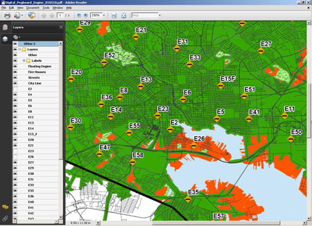
Digital Pegboard
The result of the analysis and vehicle tracking led to an important application: the digital pegboard, a geoenabled PDF used by shift commanders to determine response capabilities. The pegboard shows a map of fire stations, their service districts, and their coverage areas, using color-coded polygons that are based on a four-minute response time.
It became a tool that shift commanders used to understand the impacts of closing or “browning out” a station during any given shift; they can quickly compare volume of service in each area against a potential station closure. In 2010, Baltimore Fire began doing this type of analysis since the agency and the city were in a budgetary crisis. A new policy—rotating closures—significantly reduced overtime and actually forced the city to curtail the total number of man-hours the fire department would work without sacrificing service capabilities. This was no easy task.
Hanna generated four-minute response polygons for each fire station using ArcGIS Network Analyst to compare against incidents imported from the CAD records database. They were then exported into individual shapefiles. In essence, there was one polygon for each fire station.
Then the shapefiles were put into the digital pegboard where each station’s four-minute response coverage area could be easily turned on or off to illustrate the impact of any closure, taking incident frequencies into account. It was an application that was perfect for the designated users: fire officers, pressed to make life-and death strategic and tactical decisions. These professionals are busy meeting mission demands. They do not have time to become hands-on software users.
“Everybody knows how to open PDFs,” explains Hanna. “Fire officers were pleased because they could quickly identify where a problem existed.”
The digital pegboard was quickly adopted by agency fire officers. With the success of these and other applications, Baltimore Fire has been recognized with an Esri Special Achievement in GIS Award as well as other industry accolades.
“We’ve done a lot in a short amount of time,” says Potteiger. “Chief Clack has been very supportive. Without him, this would never have taken place.”
To learn more about how GIS is used in the fire service, visit esri.com/fire.