By Andrew Saxer
A few years ago, I moved from working as a firefighter in the area I grew up to being hired in another state. Up until then, I had only ever worked as a firefighter where I had spent my childhood riding my bike and driving around with friends as a teen. My new department has the reasonable expectation that members develop thorough knowledge of our service area to navigate without use of GPS within the city limits. With the vulnerability of spotty cell service or dead phones, being able to navigate your service area by memory with the aid of printed maps is a crucial skill. When I first started, I was given a laminated map of our city torn from the local phone book and instructed to learn it.
- Time Well Spent in the District
- TIPS FOR LEARNING YOUR WAY AROUND YOUR RESPONSE AREA
- Mayday Monday: Know Your Response Area
- Drill of the Week: Area Familiarization
I spent many hours staring at my laminated map, working with whiteout fill-in-the-blank maps. I took time on days off planning routes from the firehouse to previous calls logged through dispatch, driving around the city where I work. I made progress, but not as quickly as I’d have liked.
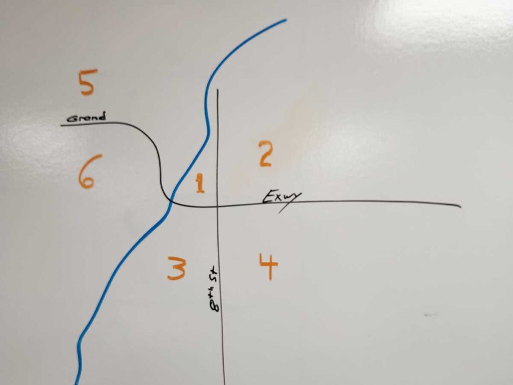
One day I saw the remnants of a rudimentary map of our city drawn on a dry erase board in our training room left by the offgoing crew (see image above). It showed the city divided into a few large areas. When I asked what it was for, a buddy on the offgoing crew told me it was the basis of a game his crew used as a company drill on street knowledge. I decided it was worth a shot as a study method myself. I liked this approach, as it first focused on “seeing the forest for the trees” as I worked toward “seeing the trees for the forest.” It made studying something of a game. I downloaded a quiz app on my phone and entered all the 200 or so street names within our city limits. I divided the city into zones that made sense to me. The app’s paid membership allowed me to take graded multiple-choice quizzes. Each session had a clear beginning and end.
On my first attempt, I scored 58%…not great. Each time I studied my map, I alternated between the two approaches. The first focused on finding streets on my map as prompted by the app’s flashcards. The second was taking multiple-choice “quiz games” coinciding with the zones those streets are found. With a month of daily practice, I made gradual improvement, consistently scoring 96% or better. I was able to quickly find all the streets on the map without needing zone or street references.
Since getting a grasp of the streets in our city, I’ve begun using this “zones” study system to learn the streets of the surrounding communities we serve. I did this in part to further test the “zones” as a stand-alone study method. Driving the area helps with landmark familiarization.
When my crewmates learned that I had success learning streets using an engaging method, they allowed me to quiz them as a crew drill. On the following shift, our battalion chief (BC) quizzed the crew as individuals, finding streets on a large map of the city hung in the apparatus bay. I demonstrated proficiency in finding a challenging set of streets, prompting our BC to become interested in the “zone” method.
During our shift, one of our crew entered a handful of streets and the corresponding zones into another application that allowed us to train as a team. Another member used their computer skills to create a polished map of the city with defining lines and zone labels to project onto the wall of the training room.
This particular application allows a group of participants to compete with each other on quizzes projected on a screen. The participants use mobile devices (phones or tablets) to log into the projected quiz. You can also take quizzes competing against fictitious competitors generated by the application, simulating the classroom drill. This app also allows for flashcard review of the entered streets, as well, still allowing me to alternate between street finding flash card drills and taking zone quizzes.
The gaming element of this approach allowed for rote memorization without the need for memory peg association systems as I’ve seen demonstrated elsewhere. Such company drill quizzes are a fun way for participants to prove their knowledge to themselves and their peers in a mildly competitive environment.
I could see this method being used for much larger and complex service areas just as easily. The only time and effort it would take is for leaders to divide up the service area into zones and enter the information into the app, and to give your crew access to this study method.
Developing this zone training method was a fulfilling team-building exercise. I appreciate the members of my crew having taken ownership in developing this study method, along with the support of our officers encouraging this effort. My hope is that members of your department find success in using this study method, as well.
Below is the lesson plan submitted to our management.
Lesson Plan: Street Zones Training
Lesson Topic:
The purpose of this training is to enable department members to better locate the named streets within the city limits on a printed map.
Class Objectives:
By the end of this training, department members will be able to study the map of the city in flashcard and quiz formats using a printed map and the database of the city streets saved on the educational mobile device application searchable under “your department.” There are 10 groupings of approximately 25 questions each. These are titles “your department Zones 1/10,” “your department Zones 2/10,” and so on.
Procedure:
The city is divided into six zones as follows (see attached reference map):
Zone 1: Northwest of the intersection of 8th Street N and E Riverview Expressway, ending at the Wisconsin River
Zone 2: Northeast of the intersection of 8th Street N and E Riverview Expressway
Zone 3: Southwest of the intersection of 8th Street N and E Riverview Expressway, ending at the Wisconsin River
Zone 4: Southeast of the intersection of the 8th Street S and E Riverview Expressway
Zone 5: North of W Riverview Expressway, West of the Wisconsin River
Zone 6: South of W Riverview Expressway, West of the Wisconsin River
Time Management:
This training can be completed within 30-minute increments as either individuals or as a crew drill.
Student Practice:
This training has two main components of student practice:
Component 1: The member studies a printed map using the above-mentioned groupings, learning in which zone(s) each of those streets lay using the flashcard option of that grouping.
Component 2: The member competes in timed quizzes with either computer generated “competitors” within the application; or a crew drill format within a classroom setting.
Andrew Saxer is a career firefighter/critical care paramedic in Central Wisconsin. He is an adjunct fire and EMS instructor in the Wiconsin Technical College System, and is a private CPR/AED, BLS, ACLS, PALS, ahd MSHA instructor. He has a bachelor’s degree in business management. If you would like help developing a street zones or other training for your agency, Andy provides consulting services. You can contact him at alivecprtraining@gmail.com

