By Scott Mlakar
There is no doubt that using unmanned aerial systems (UAS) or drones for emergency response can provide huge benefits during emergency operations as well as many nonemergency uses. Fire service agencies around the world will spend more than $800 million on drones in the coming months. In the past couple of years, many articles have focused on what you need to start a drone program, covering justifications for its use, Federal Aviation Administration (FAA) requirements for public safety agencies [certificate of authorization (COA) vs. Part 107], and proper equipment selection.
Numerous companies now will consult with your department and sell you a full package to get your UAS program started, but no one knows your needs and response area better than you. A few dedicated people who educate themselves and know where to look can obtain the same information and launch an effective program. Among the myriad of online groups dedicated to public safety UAS programs and other online resources, you can obtain a wealth of knowledge and information.
So, you have identified your needs, sold your program to city leaders, obtained funding, bought an aircraft, and got your FAA remote pilot’s license. You have let everyone know you have a drone, but are you really ready to respond? Most agencies find out it’s just not that simple. You must do much more work to build a UAS program and reap this new technology’s benefits. Your program’s success or failure depends on your ability to deliver what you promised.
We Are UAS “Pioneers”
This new specialty area is redefining the strategy and tactics used in structural firefighting, as hazmat response did in the 1980s, technical rescue did in the 1990s, and the National Institute of Standards and Technology (NIST) research on flow paths and fire behavior is doing today. We are writing the body of knowledge that will establish “best practices” as we go. I tell all our new pilots that they are writing “the book” on how to use this new technology in emergency response. Much of our knowledge comes from the use of manned aviation to support emergency operations, which is a good start, but the new technology has many other uses and features for which manned aviation is not practical.
RELATED
Authoring Your Drone Program: Choose Wisely
What Does NFPA’s Drone Standard Mean for Your Fire Department?
Training Minutes: Best Practices for Fire Service UAS
Because of the rapid pace of development and the rush to add UAS into emergency response, the public safety UAS community lacks guidance and coordination. It’s not just throwing the drone on an engine or squad and grabbing it as needed. FAA legal requirements, manufacturer updates, drone maintenance, keeping flight logs, and effectively training our pilots and using the aircraft for operations necessitate far more than what most agencies anticipated. Guidelines in the works, including National Fire Protection Association 2400, Standard for Small Unmanned Aircraft Systems (sUAS) Used for Public Safety Operations, will help going forward. The NIST Engineering Laboratory’s Intelligent Systems Division is leading the development of a comprehensive suite of ASTM International Standard Test Methods for Response Robots that includes more than 50 methods for testing remotely operated ground, aerial, and maritime systems; these methods are being incorporated into the new NFPA 2400.
My focus is on the resources that are available or are in development that can unleash the full potential of a public safety UAS team. Most importantly, public safety agencies must network and share four components of the developing knowledge base to better use drones for managing emergencies: regulatory (FAA requirements, waivers, and authorizations); hardware (aircraft, peripherals, and vehicles); software [flight, augmented reality (AR), and artificial intelligence (AI) program management]; and training/networking [establishing best practices and after action reports (AARs)].
Regulatory
As much as we all would like to just purchase a drone and fly, it’s never that simple. Two types of industries exist: one born in captivity and one born in the wild. New industries (born in the wild), uninhibited by preexisting rules, can innovate and freely operate. Aviation as it applies to UAS has been born in captivity with a long history of rules and regulations governing its use. Many have been frustrated with the FAA regulations that require public safety agencies to fly under an FAA COA (issued to a public operator for a specific activity) or under the FAA Part 107, “Small Unmanned Aircraft Regulations.” As to which is better to fly under depends on your airspace and organization; but in any case, to fly in the national airspace, you need to know the ins and outs of these regulations. Where do you get the information needed to make the right choice of regulations on which to base your program?
If you fly under Part 107 and need waivers for flights at night or for a specific airspace, what’s the best way to obtain them? What have others done to work their way through the regulations?
If you fly under a COA, are you aware of its limitations applicable to public safety aircraft? In addition, this evolves and changes quickly as the FAA tries to keep up with UAS development and to safely integrate unmanned aircraft into the national air space safely. There are some very good online and app-based resources to keep up with this and have on hand to meet the regulatory requirements. I recommend networking with your local FAA officials, too. In the sidebar “Regulatory Web Sites and Apps,” I have listed some must-have apps and Web sites to have on hand for you and your pilots. They will allow you to register your aircraft and check the airspace, the weather, notices to airmen (NOTAMs), and temporary flight restrictions (TFRs). A portal into the Web sites allows you to file the needed waivers and authorizations from the FAA. This includes the Low Altitude Authorization and Notification Capability (LAANC), which provides access to controlled airspace near airports as well as the FAA’s Special Governmental Interest (SGI) process for agencies that assist public safety agencies that may need to secure waivers or authorizations from the FAA more quickly than practicable through normal processes. These all provide a wealth of information for managing the regulatory requirements for your UAS programs.
Regulatory Web Sites and Apps
Hardware
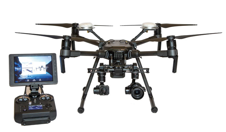
Emergency responders have a variety of manufacturers and aircraft with different capabilities and prices. A full assessment of your response area needs and your budget will dictate your selection. If you have not purchased the hardware or have purchased it but want to look at expanding your aircraft’s capability, consider the following areas. Do you need thermal capability for firefighting or searches, and does the aircraft support a model with a resolution of at least 336/30 Hz, capable for search and rescue? If it has an optical camera, can it zoom in and allow more detailed analysis from a safe position? Will you use the aircraft in interior, global positioning system (GPS)-denied environments in which size and the positioning systems become issues? What is the aircraft’s payload capacity? Does the hardware support the software you intend to use or will want to use in the future? Does it function in all weather conditions? What are the limitations? Does it have FAA 107.29-compliant lighting systems or spotlights for night operations or interior flights? Does it support first-person view (FPV) capability or allow video stream to your command center? Once you have the aircraft, where and how will it be stored and transported to the scene, and is it set up to support your operations? Knowing what questions to ask vendors or consultants before you purchase will save you a lot of aggravation and disappointment. If you already have an aircraft, now read on to see what options are available to enhance its capabilities so that your UAS team can better serve your response area. Most importantly, reach out to other agencies that have programs in place to get their opinions and feedback. Networking will allow you to get unbiased opinions on what works and what does not from agencies all over the world who have done the work. We don’t want to pay for the same mistakes twice (photo 1).
The other area of hardware that goes beyond the aircraft are the peripherals that can be added to your aircraft to allow it to fulfill different missions, such as the ability to attach and deploy a payload such as a life vest or a radio, use a spotlight or loudspeaker for search/rescue, or attach a meter for hazmat response. The fire service has developed many great additions to help us fulfill our mission and expand our capabilities. The peripherals described below are available and can be added to your UAS. A variety of companies may also have similar adaptations and features that all play a vital role in using your aircraft for multiple mission scenarios.
Thermal Imaging Cameras
Most vendors offer thermal capability, among other public safety options. A dual optical and thermal unit with multispectral dynamic imaging is available from one manufacturer at an entry level price, making thermal imaging cameras (TICs) attainable for most departments starting a program. Lower-resolution cameras work well when you can fly closer in to your search area or can quickly identify a potential target for ground crews to follow up on, but it’s not a replacement for a higher-resolution camera at 336 or 640 resolution or above. Higher-resolution TICs come at a price. I would recommend at a minimum a camera that has at least 336 resolution running at 30 Hz for advanced search and rescue operations. If your budget does not allow this, you can use the less costly models with aftermarket mounts that attach to your airframe. Such a system has a 5.8 Mhz transmitter used in the drone racing market, which sends your image down to a ground-based receiver and monitor separate from the aircraft’s flight screen. There are many online tutorials that show how to do this; it is a viable option for teams on a budget. When looking at hardware, determine which camera options are available. Consider which aircraft support multiple camera types according to the mission when assessing hardware.

(1) Photo courtesy of DJI.
(2) Photo by author.
Payload Systems
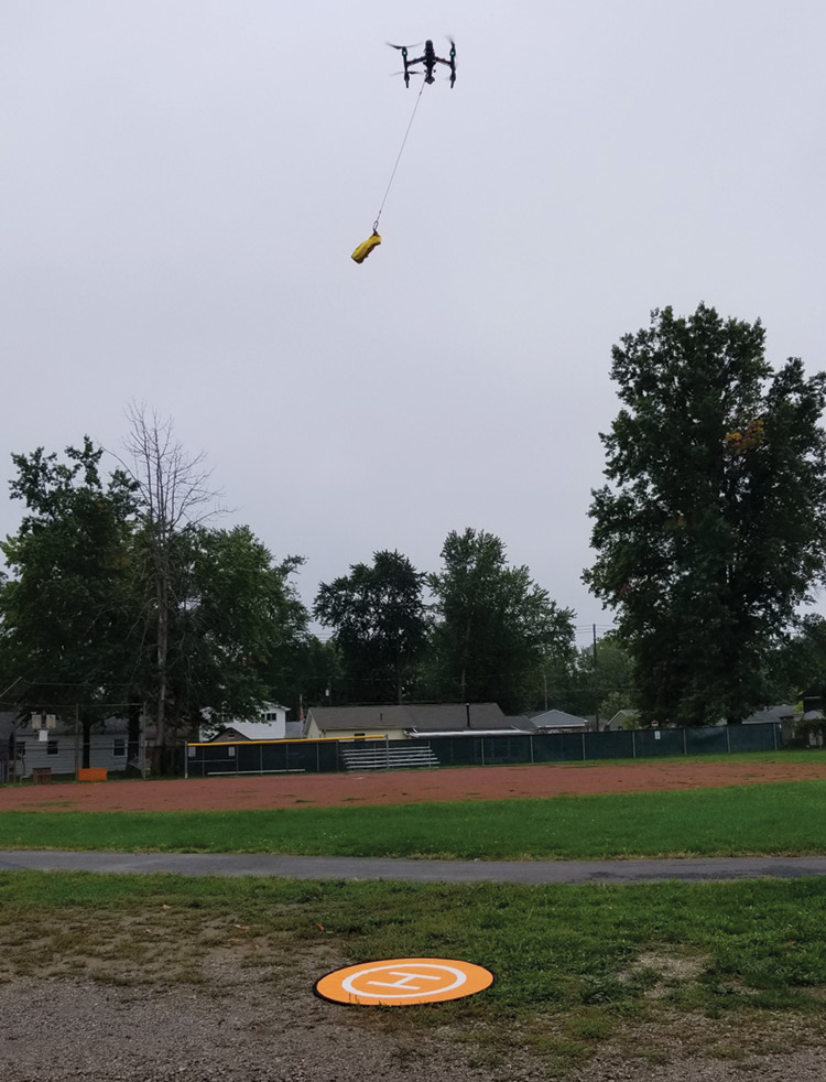
Another option that can be added is payload delivery. Smaller drones have very small payload capabilities, and this may not be possible. The larger aircraft can usually carry anywhere from two to four pounds, enough to deliver a life jacket or a radio or even deploy tag lines for rope and water rescues. Various models offer this feature. Network with other public safety teams to see which works best for your operations (photo 2).
External Mounts
Another desirable accessory is the ability to mount additional cameras, sensors, or lights. This includes light detection and ranging (LIDAR, a remote sensing method that uses light in the form of a pulsed laser to measure ranges), panoramic cameras, spotlights, strobe lights, and air-monitoring equipment. Several manufacturers offer commercial mounts, and you can assemble your own with the myriad of camera mounts in the market. The mounts can be adapted to multiple uses and payloads. One last note on mounts: Many hobbyists upload 3-D printable parts and mounts on Web sites like Thingsverse and Stlfinder. You can print these quickly and locally, and there is no lack of creativity when it comes to what people design and share.
Second Screen/Streaming
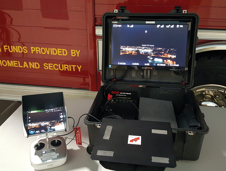
One must-have is the capability for second-screen or video streaming. The FAA requires that you always maintain visual line of sight with your aircraft. With this in mind, when you are doing a search or providing overwatch on a fire scene, you need that second set of eyes to watch the aircraft or your screen, forwarding any pertinent information by the radio to command. The FAA calls this person a visual observer (VO). What is most effective is to have the pilot focus on the aircraft and airspace. The VO is thus available to watch a video feed and handle communications. Instead of having the VO try to look over the pilot’s shoulder, you need a second-screen setup, which could be a set of FPV goggles or a second radio controller (RC) and screen for your VO. Use a larger video screen so your command staff can view it effectively. A larger screen offers better visibility and it gets the command staff away from the pilot, eliminating distractions. This second screen can be wired or a wireless monitor mounted in a vehicle or a portable case. It is simple to make, and directions to build one are available on most forums or YouTube. Wireless streaming to remote locations is possible through an app on certain products that allows streaming to popular live streaming platforms like YouTube and Facebook or to secure streaming services. Certain modules allow you to stream to smartphone tablets and secure Internet pages (photo 3).
Software
Software development designed specifically for public safety aircraft is the most exciting area of UAS. Like the first smartphones, which provided a platform, the manufacturers opened up the full capability of the device by reaching out to and encouraging software developers to make applications (apps) to run on the platform. One manufacturer is the one to which the public safety sector has gravitated and where most of the software development has evolved. Although I understand the concerns that some may have with digital security and their flight information, the manufacturer accounts for 70 percent of the commercial and consumer sales. Software has been developed or is developing around their platform that will unleash your aircraft for public safety use with the following capabilities: live streaming back to your command center; augmented reality that overlays all your GIS data including hydrants, water and gas lines, and preplan information; and identifying responders on the ground right onto a pilot’s UAS screen (photo 4).
(3) Photo by author.
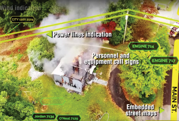
(4) Photo courtesy of EdgyBees.
In search and rescue, AI allows your aircraft’s sensors (optical, thermal, LIDAR) to pick up heat, colors, shapes, or behaviors and alert the pilot on his screen. With photogrammetry, aircraft can provide detailed 3-D images for fire investigations, traffic accident reconstruction, flooding, wildfire response, and forestry management. With UAS mapping software, aircraft can fly automated autonomous grids for search and rescue and in fire investigations and take pictures for detailed analysis back at the command post. “UAS Networking Groups” below lists some of the software packages that are available or are being developed for public safety to greatly enhance the capabilities of your aircraft and team.
Several new software applications have an operations center that allows anyone in your organization to view live pilot sessions (up to four aircraft). Multiple users can work together seamlessly through chat and by marking points of interest. Incident commanders can task pilots directly by assigning waypoints or search areas with a simple touch of their maps. It includes a pilot app to fly and run autonomous missions and an air base that is UAS program management.
AR and AI
An AR app overlays your live drone video with geo-information layers including maps, building layouts, points of interest, people, and user-generated markers. It can be shared with incident command and ground units through the app on their smartphones. On select platforms, live streaming is available. Flight software is incorporating AI that allows drones to scan and map the terrain of buildings, drop supplies to disaster victims, assess structural damage after a disaster, help locate the exact seat of a fire, aid at chemical spills and runoff, and locate lost or injured people. AI can identify suspects using facial recognition and spot violent behavior in large crowds.
Search and Rescue
Software takes over the difficult task of flying search patterns while trying to analyze images, allowing pilots to focus on the important task of locating the victim. Using an advanced algorithm, it allows the pilot to generate a suitable flight plan over the area of interest, allowing for autonomous flight from take-off to landing. When a possible target is identified, the software sounds an alert, which pops up on the pilot’s screen, and provides GPS information. This allows the pilot to place markers of potential targets and to share in real time with search units on the ground.
Mapping/3-D Modeling
An app or PC-based waypoint mission engine offers a powerful tool for mapping. This allows for the creation of detailed maps and 3-D models to use for fire investigations, crime scene documentation, and mapping disaster areas. This type of mapping was used extensively for emergency planning and management during the Camp Fires in California.
UAS Networking Groups
These resources offer assistance in developing and running a UAS program and free online Web-based training sessions.
Facebook Groups
Web Sites
Training/Networking
No other area is more important than the training we provide to our teams. Public safety agencies must network and share UAS training and mission information. Developing an initial and ongoing training platform is critical to your success, and the strength of the fire service has always been our willingness to share the content that we develop; this is especially true for training pilots in UAS. By identifying and participating in the online social media groups, you will make contacts who are always willing to share material to help you build a training program. A myriad of online fire department videos demonstrate best practices and tests.
Another critical component is the AAR, which helps you identify what’s working, what’s not, and where you need additional training. This originated in staffed aviation and the military as a way to document where you responded, what you did, and what lessons you learned. We know it in the fire service as a hotwash or incident critique. AAR helps with aircraft internal maintenance and repair record keeping. This is essential to ensure your aircraft is maintained and that small issues don’t become large issues. The FAA also expects this information to be available in an emergency. Sharing this information keeps you and others from paying for the same mistake twice. AARs are a tool we should use on every mission to improve. Use the information in the “UAS Networking Groups” sidebar to network with other agencies for unbiased opinions from agencies worldwide. Most are social media groups and Web sites dedicated to sharing information and innovations; they are made up of fire, police, and commercial operators who are knowledgeable. If you need a slideshow, have a question on hardware, need a standard operating procedure, or want to consult when your equipment is not working, just ask and then watch the power of social media at work.
So, now you have a drone and instead of just flying around with no plan or purpose, you now have some tools to assist you in developing your UAS program to its full capability. By educating yourself and sharing information, you can establish the knowledge base needed to fully integrate UAS into emergency operations. This technology is changing the way we respond and is becoming an essential tool in managing emergency operations. We all have a responsibility to ensure it’s done safely and effectively.
SCOTT MLAKAR is an assistant chief of the Willoughby (OH) Fire Department, where he has served for 34 years. He is a paramedic, hazmat technician, technical rescue coordinator, and fire investigator and serves on the Fire Chief’s Special Operations Committee in Lake County. He developed and oversees operations of the Lake County Public Safety Unmanned Aerial Systems (UAS) team, composed of fire and police officers, which provides UAS support to all of Lake County’s emergency services and special teams.

