By E.M. “Sonny” Stiger and Rocky Infanger
Photos by Audrey Todd
POOR MAN‘S FARSITE
FARSITE is a sophisticated fire area simulator computer program designed to simulate fire growth using existing models of fire behavior found in the BEHAVE Fire Behavior Prediction and Fuel Modeling System (Andrews 1986), and in the Canadian Forest Fire Behavior Prediction System (Forestry Canada Fire Danger Group 1992). Many users consider FARSITE to be data-bound and too cumbersome for daily operational use. The authors have used a simple procedure that works.
A computer program by Map Tech, Terrain Navigator Pro, used in conjunction with BEHAVE PLUS has provided a relatively accurate and fast wildland fire projection method. Terrain Navigator Pro is a digital topographic map and aerial photography collection system; BEHAVE PLUS is a fire behavior modeling system. Any qualified fire behavior analyst or experienced local firefighter with a strong fire behavior background who has a working knowledge of the BEHAVE program and is familiar with the local fuels, weather, and topography can use the following procedure. The programs are immediately available for use in real time as a support to the fire incident management team from initial attack to a Type One incident. This procedure was tested in 2006 and 2007 on wildland fires in and around Lewis and Clark County, Montana, by E.M. “Sonny” Stiger, fire behavior analyst (FBAN), and Rocky Infanger, chief Wolf Creek/Craig Fire Service Area. The results have been impressive.
Following are three examples of how the method can be used in fire management operations for initial attack, extended attack, and large fire management.
.jpg)
(1) A photo of the Black Beach fire near Wolf Creek, Montana, on August 21, 2012.
Initial Attack
With the first fire report, note the location either by landmark, address, latitude/longitude, or township and range. Terrain Navigator can locate your fire with any of these inputs on its database. The computer program will highlight the fire origin either on a contour map or an aerial photo, or both at the same time, in either flat map or 3-D. The next step is to determine the fuel model and potential for crowning (ladder fuels, crown closure, and so on.) by experience, local knowledge, and/or the Terrain Navigator aerial photo.
Next, determine the wind speed and direction from on-site personnel, an air observer, the nearest weather station, or Remote Area Weather Station (RAWS). Several agencies now maintain RAWS stations with the data available via the Internet.
Determine the percent slope using the Terrain Navigator program.
.jpg)
(2) Rocky and Sonny brief unified command on the Black Beach fire.
.jpg)
(3) A photo ofthe computer screen shows the use of Terrain Navigator Pro for a part of that briefing.
Compute one hour fine fuel moisture using the temperature and relative humidity from the nearest RAWS. If the 10- and 100-hour fuel moistures are needed for your selected fuel model, the nearest fire weather station indices can be estimated to fit the fire site conditions. Live herbaceous and live woody fuel moisture can be determined similarly using fire behavior tables and the nearest fire weather station indices.
With the above inputs, run BEHAVE for estimated rate of spread (ROS) and flame length. These two outputs are critical for the initial and quick evaluation of a fire’s potential. Inputs can also be estimated for the potential of an active crown fire and its ROS, as well as for spotting distance and the probability of ignition for spot fires (See the resources section at the end of this article, particularly RMRS-GTR-145, Stereo Photo Guide for Estimating Canopy Fuel Characteristics in Conifer Stands.) Note: Behave Plus for projecting crown fires is still in a trial mode. All computed ROS must be analyzed based on experience.
You can use this procedure to project a fire for several hours into the future. The Terrain Navigator program provides a method for drawing the projected fire perimeter on the maps and/or aerial photos, marking areas of concern for firefighters. These maps can be printed out or e-mailed in one dimension or in three dimensions. For a detailed description of using the Terrain Navigator program for this purpose, contact Justin Randall at randallju@yahoo.com, author of Map Tech Terrain Navigator Pro 7.0 Uses and Limitations in Fire Management, University of Montana, Forestry 496, Wildland Fire Science Independent Study, Fall 2006.
You can accomplish the above steps in a relatively short time depending on your experience level and the quantity of on-site data. As quickly as fire crews can relay fuels, weather, and topography data from the fire, you can quickly update the BEHAVE run and refine the Terrain Navigator maps. Canopy height, tree height, and canopy base height from crews on the fire line can further refine the potential for an active crown fire.
The following is an example of an actual time line from the Sugarloaf Initial Attack Fire on 7/24/06.
1430 hours: Fire reported in Stickney Creek drainage.
OFFICE: Activate Terrain Navigator Pro and note fuels and topography of general area. Record weather from RAWS.
1448 hours: Initial Attack Crew reports “pretty good column.” “Fire is south/southwest of Sugarloaf Mountain down in the draw.”
1452 hours: Air Observer gives Lat/Long.
OFFICE: Fire is located on map and aerial photo using Terrain Navigator. Calculate slope, note aspect and alignment of drainages relative to wind direction. Request size-up by air observer.
1454 hours: Air pbserver reports fire spread moderate, upper 1/3 of slope in grass and sparse timber. Smoke drift is to the east.
1515 hours: Maps and aerial photos have now been printed with fire origin located.
The map and aerial photography can be printed in 3-D.
OFFICE: Run BEHAVE using the current Fire Weather Forecast, RAWS data, current fire danger indices, and vegetation estimates.
1544 hours: Initial BEHAVE completed with preliminary Terrain Navigator one-hour spread map.
1600 hours: Using Terrain Navigator and BEHAVE, an extended four-hour spread map (showing one-hour increments) has been completed. This information will be used in the initial briefing of management. Our local sheriff is also the county fire warden and is responsible for evacuations. His comments as a user of this procedure is that it is just as important to know where the fire is not going as it is to know where it is going when dealing with evacuations.
1725 hours: Using information from crews on the fire line and a spot fire weather forecast, BEHAVE was updated and the Terrain Navigator maps refined.
It is important to note that as experience was gained using Terrain Navigator, this time line was significantly reduced.
Extended Attack
Two fires will be used to illustrate the use of the procedure for extended attack. The 2,700-acre Cigarette Rock Fire in September 2006 and the 570-acre Little Wolf Creek fire in July 2007.
By 1000 hours on September 13, 2006, the Cigarette Rock fire was estimated to be 300 acres and had just crossed Straight Creek.(Figures 1 and 2). The procedure was initiated at this time using the weather data and indices from the benchmark fire weather RAWS approximately four miles due north of the fire and the special red flag warning issued the morning of September. 13. See figures 3 and 4 for results of the procedure. The potential fire perimeter projection was almost identical to the actual final fire perimeter. The actual final size of the fire was 2,700 acres.
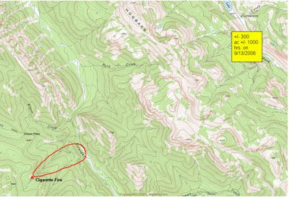
Figure 1: Maptech topo view, Cigarette Rock Fire
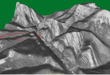
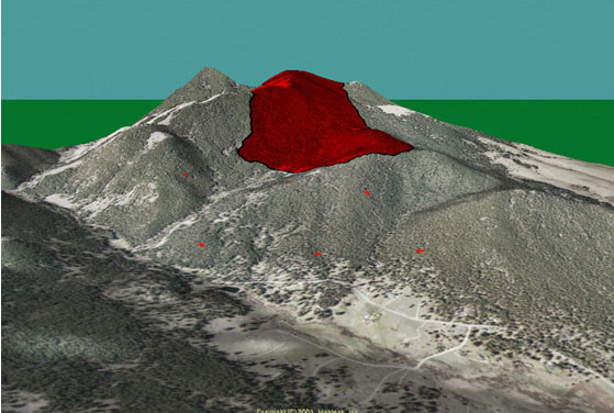
Figure 2: 3D view, Cigarette Rock Fire.
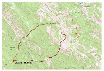
Figure 3: Projected spread of Cigarette Rock fire.
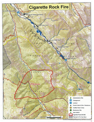
Figure 4: Actual final perimeter of Cigarette Rock Fire.
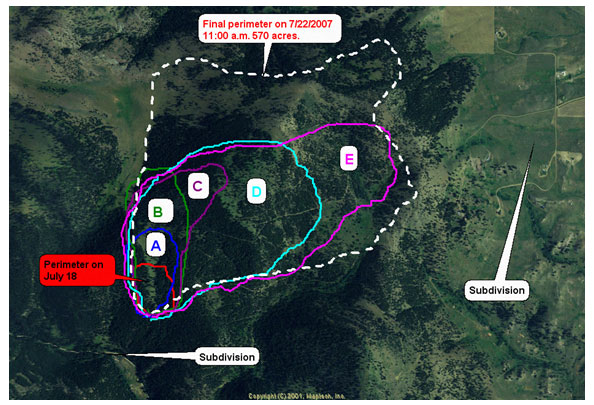
The Little Wolf Creek fire occurred on July 18, 2007, and, because of the number of year-round homes threatened, was included in the complex of fires being managed by a Type One Incident Management Team (IMT) on July 21, 2007. However, prior to that transition, the fire was managed by the local volunteer fire departments and the State of Montana fire services. The fire projection was started immediately on the first alarm (Map 1). Again, the projected fire perimeter was very close to the actual final fire perimeter three days later. The final estimated fire size was 570 acres. The projection maps and aerial photos were used to brief the extended attack overhead as well as the incoming Type One IMT and the sheriff. It is quite obvious that there are safety, tactical, and evacuation planning benefits when using this procedure.
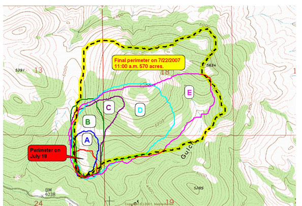
Map 1: Projected fire spread of Little Wolf Creek fire, including final perimeter.
RED — Actual Perimeter on July 18, 2007 – +/- 17 acres
(A) BLUE — A (10:00 a.m. 7/19/07) PROJECTED — +/- 35 acres
(B) GREEN — B (12:00 p.m. 7/19/07) PROJECTED — +/- 75 acres
(C) PURPLE — C (2:00 p.m.7/19/07) PROJECTED — +/- 90 acres
(D) SKY BLUE — D (4:00 p.m.7/19/07) PROJECTED — +/- 243 acres
(E) PINK — E (6:00 p.m. 7/19/07) PROJECTED — +/- 340 acres
BLACK dash w/ YELLOW highlight (7/22/07 11:00 a.m.) — ACTUAL Final Perimeter – 570 acres.
Map 2: Evacuations in nearby subdivisions included 75 to100 homes.
Large Fires
The Meriwether fire was reported as a small lightning fire on July 17, 2007. Because of extreme burning conditions and difficult access, this fire grew to 43,298 acres. The fire was managed by a Type One IMT. The author was retained to assist the team fire behavior analyst with fire behavior duties as a local fire behavior analyst. The Terrain Navigator Program coupled with BEHAVE PLUS was used to project the daily potential spread of the fire. The location of hot spots from infrared flights and debriefing line personnel provided the starting point for projections. The results were very accurate and reliable for use in daily briefings.
Training and Public Education
The same procedure can be used to illustrate a wildfire’s potential using historical weather and fuel moisture data from a nearby fire weather station. This procedure was used for the city of Helena and in several communities near the capital city. The results were placed into a PowerPoint presentation and used for training local volunteer fire departments and educating residents for the need to provide defensible/survivable space around homes in the wildland-urban interface (WUI). The program prepared for the city of Helena was instrumental in convincing the planning staff and zoning board to propose a WUI zone that would prohibit shake shingle roofs along with requiring screening over vents and so on. This zoning proposal was approved by the city commission on January 7, 2008, and represented a major step forward in WUI fire safety in Lewis & Clark County.
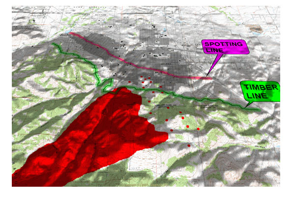
Projected fire with spotting potential moving into Helena, Montana (state capital).
This fire projection method has proven to be very useful in a multitude of fire management operations from suppression to training and education. As we gain more experience in using this method, its efficiency and accuracy will improve, making it an even more valuable method.
The question, “Why bother/” is answered quite well by Risa Lange-Navarro, Northern Rockies Training Center-Missoula, Montana.
“Fire behavior can be extremely complicated, but if you can get a good overall understanding of fire behavior, you will be able to make more efficient and safe decisions to suppress or manage fires and bring everyone home at the end of the assignment.”
.jpg)
E.M. “Sonny“ Stiger (left) is a retired fire chief, a fire behavior analyst, and a fuel and fire management consultant
Rocky Infanger (right) is the fire chief of the Wolf Creek/Craig (MT) Fire Service Area.
RESOURCES
The following publications can be used to estimate input to the BEHAVE program and operate Terrain Navigator Pro for fire management purposes.
- INT-GTR-122 (APRIL 1982)
Aids to Determining Fuel Models for Estimating Fire Behavior.
22 p.
Hal E. Anderson
- INT-GTR-142 (APRIL 1983)
Field Procedures for Verification and Adjustment of Fire Behavior Predictions.
28 p.
Richard C. Rothermel
George C. Rinehart
- INT-GTR-143 (JUNE1983)
How to Predict the Spread and Intensity of Forest and Range Fires.
168 p.
Richard C. Rothermel
- RMRS-GTR-145 (MARCH 2005)
Stereo Photo Guide for Estimating Canopy Fuel Characteristics in Conifer Stands.
56 p.
Joe H. Scott
Elizabeth D. Reinhardt
- RMRS-GTR-153 (JUNE 2005)
Standard Fire Behavior Fuel Models: A Comprehensive Set for Use with Rothermel’s Surface Fire Spread Model.
80 p.
Joe H. Scott
Robert E. Burgan
- RMRS-RP-29 (SEPTEMBER 2001)
Assessing Crown Fire Potential by Linking Models of Surface and Crown Fire Behavior.
66 p.
Joe H. Scott
Elizabeth D. Reinhardt
- INT-GTR-438 (JANUARY 1991)
Predicting Behavior and Size of Crown Fires in the Northern Rocky Mountains.
46 p.
Richard C. Rothermel
- 790039181 (FALL 2006)
Map Tech Terrain Navigator Pro 7.0 Uses and Limitations in Fire Management.
46 p.
Justin D. Randall

