Prescribed Fire Proves Effective at Urban Interface
features

Photos courtesy of Los Angeles City Fire Department Photo Unit
On November 6, 1961, a brush fire destroyed almost 500 homes and consumed over 6,000 acres in the exclusive Bel Air section of Los Angeles, CA. Two days later, after the last ember had been extinguished and damage assessments had been completed, it was determined that $24-million in insured property loss had been sustained. The Bel Air fire would go down in history as the single most costly disaster in California since the San Francisco earthquake and fire in 1906.
The early-morning fire was of unknown origin and started just north of Mulholland Drive, which is at the north end of Stone Canyon (see map). Within minutes, the flames leaped Mulholland Drive. The fire, now with a front exceeding 1,000 feet, moved south along the west slope of Stone Canyon. Fire brands, carried by winds gusting to 50 mph, set numerous spot fires as far as V mile downwind. Flaming embers landed on wood shingle roofs, and structures were soon lost to the fire.
Brush fires are not a rare occurrence in Los Angeles. Within the city limits there are 130-square miles of steep, brush-covered hillsides that contain over 50,000 homes. Since 1961, eight disasterous brush fires have swept through the Mountain Fire District destroying over 700 homes and almost 27,000 acres of watershed.
In 1984, the Bel Air residents noticed that the chaparral* in Stone Canyon had regrown to the size and density that it was before the 1961 fire. If that fire were to occur today, the property loss, at today’s values, would amount to over $500-million, more than twice as much as in 1961. Area residents decided to take action to avert another similar disaster. The homeowners’ association formed a fire committee to investigate the possibility of reducing the fuel load in Stone Canyon.
The Los Angeles Department of Water and Power (DWP) owns the majority of Stone Canyon. In the bottom of the canyon are two reservoirs that provide drinking water to the western part of the city. Surrounding the two reservoirs are 600 acres of undeveloped, chaparral-covered slopes. The Bel Air fire committee approached the DWP with a request to develop a brush management program to reduce the fuel load on DWP property in Stone Canyon.
A series of meetings to discuss a plan of action followed. In November 1984, the DWP presented the homeowners with a proposal that listed ten elements of a brush management program:
- Provide 100 feet of brush clearance from any structure adjacent to DWP property.
- Maintain four west-side firebreaks.
- Clear brush from around all wooden power poles on DWP property.
- Mow annual grasses and weeds on flat areas in canyon bottom.
- Maintain ten fire hydrants along westerly patrol road.
- Where adjacent property owners clear their brush to the DWP property line, DWP will clear an additional 100-200 feet.
*Chaparral is a common wildfire fuel found throughout southern California. It is a dense and sometimes impenetrable thicket of evergreen oak in the form of bushes and dwarf trees. It flourishes in climates of dry summers and moist winters.
- Clear brush from under all power lines traversing DWP property.
- DWP and the fire department will jointly evaluate the feasibility of brush thinning in selected areas.
- Evaluate the feasibility of replacing native chaparral with lowgrowing, fire-resistant vegetation in selected areas.
- Consider joint venture programs with adjacent homeowners to perform additional mutually agreeable work.
By May 1985, the DWP completed all ten elements of their proposal and reported back to the Bel Air fire committee. One of the DWP’s findings was that the feasibility study in item Number 8 indicated that selective thinning was not cost effective due to access problems. Even though the DWP had spent over $25,000 to complete the other nine elements of their proposal, the committee was dissatisfied because there were still 600 acres of 23-year old brush in Stone Canyon.
The committee took their concerns to the mayor and city council. In June 1985, the mayor of Los Angeles directed the fire department and DWP to do something about the brush in Stone Canyon. Faced with the prospect of spending millions of dollars for brush clearance in Stone Canyon, as well as annual maintenance costs, the agencies were forced to investigate other methods of fuel reduction.

In July 1985, Los Angeles City Fire Chief Donald Manning and his staff met with Dr. Philip Riggan, a research scientist with the United States Forest Service (USFS). Dr. Riggan presented infrared photographs and digital imagery of the Santa Monica mountain range in Los Angeles. The photographs, which were taken from 60,000 feet in the air from a converted U-2 spy plane, clearly depicted the old-age and decadent fuels existing in the midst of the city’s exclusive and affluent hillside areas. The photographs indicated that one of the worst areas was Stone Canyon.
Dr. Riggan invited Chief Manning and the Los Angeles City Fire Department to join the USFS, the California Department of Forestry, and the Los Angeles County Fire Department in a research and development project to conduct experimental prescription burns in highly populated brush areas. Although the City Fire Department policy was against controlled burning as a method of fuel reduction in populated areas, Chief Manning saw Dr. Riggan’s invitation as an opportunity to address the needs of the Bel Air homeowners.
The “Stone Canyon Fuel Modification Committee” was comprised of members from each of the four agencies. The stated purpose of this ten-member committee was to explore methods of reducing the fire hazard in the Stone Canyon area. The first meeting, held in September 1985, was essentially a “brainstorming and problem solving analysis.”
During this brainstorming session, the committee members discussed several methods of fuel reduction, and eventually prioritized them according to operational and economical feasibility. The methods discussed were:
- Small increment prescribed burns (under 50 acres);
- Pile burning — debris from hand thinning;
- Selective thinning and removal from site;
- Chipping — chipped debris dispersed back into cut area;
- Crushing — tractor to crush fuel in specific areas of access;
- Chaining—degrades fuel but does not eliminate the dead debris;
- Vegetation replacement — very costly and there is no guarantee that the vegetation selected will provide improved protection;
- Type conversion—generally unwise because the area reverts to buckwheat and sage, with undesirable fire properties;
- Grazing with livestock—last ditch effort with little results.


Photos courtesy of Los Angeles City Fire Department Photo Unit.
Since this would be a research project, the committee decided that it would be best to use a combination of methods. Each method used would be documented and evaluated throughout this threeyear program to see which one produced the most desirable results.
The committee recommended that the four agencies form a “Cooperative Interagency Fuel Management Research Development and Application Program.” The agencies would combine their resources under the umbrella of the Los Angeles County Fire Department’s “Coordinated Resource Management Program” (CRMP).
During the second meeting, the committee formulated the “Goal and Objectives of the Stone Canyon Project.”
The goal was to reduce the probability of uncontrolled wild land fire in the Stone Canyon area while preserving the ecosystem through a cooperative interagency program.
The objectives were as follows:
- Establish agency agreements that include liability and funding concerns by February 1, 1986.
- Identify and prioritize fuel modification areas in Stone Canyon by December 1, 1985.
- Develop a pre-treatment and fuel analysis plan for fuel modification starting October 25, 1985, and continuing through the action plan time frame.
- Define methods of fuel modification for each specific area identified in the project by February 1, 1986.
- Develop and implement an action plan with specific tasks and time frames established by January 1, 1986.
- Evaluate the effectiveness of the program through written and visual documentation. This evaluation will be ongoing through the life of the project.
- Seek input and assistance from homeowner groups and other citizens, and provide continuing coordination starting October 31, 1985.
In later meetings, Stone Canyon was divided into eight treatment areas (see map), and methods of vegetation management were assigned to each area. Plans were made for tractor crushing and hand clearance within 300 feet of structures. Agreements were drafted and signed, and liability agreements were initiated.
The action plan called for a three-year project life. It was decided to burn 120 acres in the north end of the canyon during the first year. After the burns, the area would be monitored for one full year to evaluate the results of the burn.
Research scientists from the USFS and the University of California at Los Angeles (UCLA) would be looking at sedimentation in the reservoirs, erosion caused by winter rains, and vegetation reproduction. If undesirable effects resulted, the committee would consider changing the burn plans and selecting alternate methods of treatment for future burns.
After the burn plan was completed, copies were sent to the participating agencies for their approval. The plan called for a 300-foot hand-cleared buffer zone around all structures adjacent to the proposed burn area. It was decided that brush could be hand cleared and piled in the cleared area. The piles of brush would be burned on an overcast, cool, drizzly day when there was no possibility of fire spreading to the adjacent standing brush.
The committee held meetings with homeowner groups from throughout the surrounding areas to inform residents of the proposed project, to listen to their ideas and concerns, and to gain their support. News releases were prepared and distributed to the media and press. A presentation was made to the Los Angeles City Council describing the project and safety measures to be taken to prevent an escaped fire. Finally, in April 1986 all of the planning had been finalized, and the work could begin.
The USFS staff began documenting the vegetative fuels in Stone Canyon. They collected information on species, distribution, age, live-to-dead ratios, and biomass. County fire department inmate crews began hand cutting and piling brush in the areas adjacent to structures. City and county tractor crews began crushing brush along ridges and hogbacks and in areas where it was doubtful that a fire could be generated due to high moisture fuels.

Photos courtesy of Los Angeles City Fire Department Photo Unit.
It was planned that the piles of cut brush would be burned on an overcast, high-humidity, no-wind morning. On a day in late May 1986 the weather cooperated and provided the necessary conditions. Five city engine companies were requested for standby, and county camp crews provided the ignition forces. The piles of cut brush were burned without incident. The smoke lifted into the overcast sky and presented no problems. Property owners who were in the immediate area were not even aware that a burn was being conducted.
The initial hand clearance and burning of cut brush provided a full 300 feet of clearance between the standing brush and adjacent structures. It now appeared that the prescription burns could be done safely without fear that the fire might damage nearby homes.
In early June the live fuel moistures of the brush was much too high to have a successful burn. Fuel moisture in chamise, ceanothus, and laurel sumac, trees, shrubs, and woody vines, were running 160-175%. It was now a matter of waiting until the brush and the weather were both within the window of the prescription. Fuel moisture samples and weather forecasts indicated that conditions would be right by the end of June.
Just before the actual burn days, local engine companies distributed flyers throughout the neighborhood that informed homeowners of the proposed dates of the burn and warned them to expect smoke in the area. Public service messages were aired by local radio and television stations. In order to record actual soil temperatures during the burn, the USFS research people placed thermocouples in the soil in the burn area.
On June 30 and July 1, 1986, the combined forces of the city and county fire departments successfully completed small increment prescribed burns in the north portion of Stone Canyon.
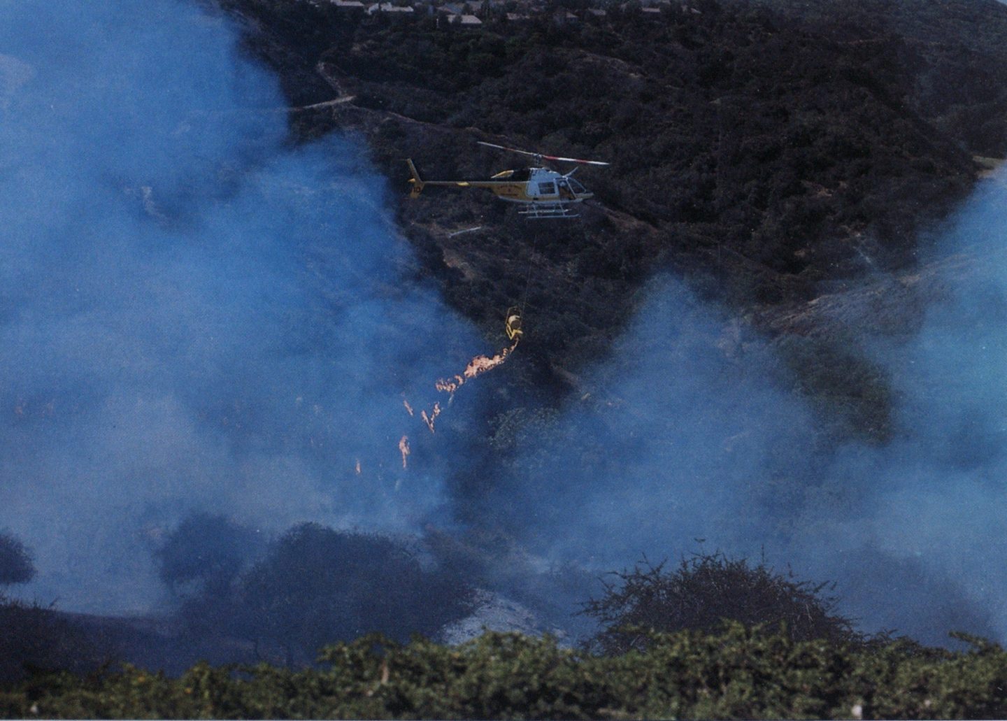
On the first day, 26 acres were burned in the northeast corner of the project. This section consisted of an east facing slope with a small, two-acre canyon that drains to the southeast. The area was strip burned with a helitorch starting at the north end of the slope and stripping toward the south.
The helicopter pilot was very accurate with his drops and was able to take strips approximately 50feet wide. Because the wind was coming from the south at 7-8 mph, each strip burned into the previously burned area. In this manner, the fire was kept at a minimum intensity and could not develop an uncontrollable run with the wind.
The second burn was conducted on the following day. It was intended to burn only 30 acres per day, but the brush and weather cooperated so well that the burn continued into the afternoon. As it turned out, 94 acres were burned, and we reached the first year’s goal of 120 acres.


Photos courtesy of Los Angeles City Fire Department Photo Unit.
The resources that were committed to these prescribed fires were above and beyond what was actually needed to contain them. This excess protection was assigned because this project was the first one to use the helitorch in an area of concentrated urban development. It was also the first prescribed burn in such close proximity to residential occupancies. The city fire department committed 15 engine companies, three helicopters (two water drop and one for observation), one bulldozer, four battalion chiefs, and one assistant chief. The county fire department provided ten camp crews, supervisors, and one helicopter to operate the helitorch.
The DWP paid all of the direct costs for the project. The out-ofpocket expenses were as follows: $42,000 for 120 camp crew days, $16,000 for a study of sedimentation production by UCLA, and $15,000 to the USFS for research and for U-2 flights for aerial pictures (infrared telemetry).
The indirect costs of the project, which totaled about $107,000, were absorbed by the city and county fire departments. Indirect costs included the expenses for fire suppression units, tractor crews, and helicopters. Since on-duty, first-line units were used for the burns, the salaries and equipment costs would have been paid anyway.
The total cost for the first year’s burning was about $1,500 per acre. When compared to the cost of hand clearance — $3,000-$5,000 per acre — prescribed burning proves to be a very cost effective method of reducing the wildfire potential at the urban interface.
Later this year and next year, the west and east sides of Stone Canyon will be prescribed burned. The committee members feel that with the experience gained from the 1986 burn, the remaining portion of the canyon can be burned safely and without incident.
Wildfires have been part of southern California for all of recorded history. Each year the urban sprawl encroaches more and more into the brush covered hillside areas, increasing the threat of property loss from wildfires. Wild land fire managers must find new cost-effective methods for preventing property loss from the fires that are inevitable.
The Los Angeles City Fire Department has one of the most effective brush clearance programs in the state. Since the program was implemented in 1981, property loss from brush fires has been reduced significantly. However, the brush clearance laws in Los Angeles only address brush and hazardous vegetation that are within 100 feet of structures. Chief Manning recognizes the need for vegetation management on those hillsides within the city that are not covered by ordinance.
Prescribed burning has proven to be a valuable, cost-effective fire management tool for creating oldage fuel mosaics in undeveloped wild land areas. The knowledge that was gained from the Stone Canyon research project will be valuable to all fire protection agencies that are faced with the problem of extensive urban development in known wildland fire corridors.