By Vicki Schmidt
Whether it’s a simple fender bender multi-vehicle crash or an incident involving significant resources, mitigating roadway hazards is a major concern for conscientious chiefs and commanding officers. And while the term immediately dangerous to life or health is reserved for the need to use self-contained breathing apparatus, roadway incidents are a leading threat to firefighter and first responder life safety. Yet even in the best of communities where citizens, the fire department, and law enforcement officials cooperate well, the mention of closing down a road to secure a major incident scene is sure to raise the stress level of all involved.
Just as with preincident planning for a major fire or emergency evacuation, preincident planning for detours removes a level of stress and replaces it with a level of sufficiency and confidence. Well-thought-out and documented preincident plans allow for automatic, succinct, and efficient actions to take place once an incident is toned out. Imagine how much more positive a size-up over the radio sounds when incident command communicates, “We’re setting up the preplanned detours,” as opposed to “We’re closing down the road.”
Permanently signed detour routes are common on multilane and interstate highways, as are predetermined detour routes for long-term interruptions such as major construction projects. First responder units can mirror these same actions within their jurisdiction to plan for traffic detours that reroute traffic around extended emergency incidents. With this as your goal, establishing a local roadway detour routing program for your fire department takes a few steps.
First, prioritize the intersections or areas where accidents or incidents have a significant impact on traffic flow. These target roadway hazards usually fall into two categories:
- Areas where several major incidents occur annually
- Areas where an incident at a specific time of day would have a major negative impact on traffic flow, such as a bridge crossing or intersection at rush hour.
Second, determine which target roadway hazards areas have viable options for detours. Laws in many jurisdictions dictate activation of a detour route if the incident involves such variables as multiple severe injuries, the death of a person, or the need for crime scene investigation. Responder safety is also a valid cause, and in all cases, interagency communication is essential. All appropriate police, first responders, and authorities as noted in department standard operating guidelines (SOGs) should be advised by the incident commander as soon as the decision to implement a detour route has been activated.
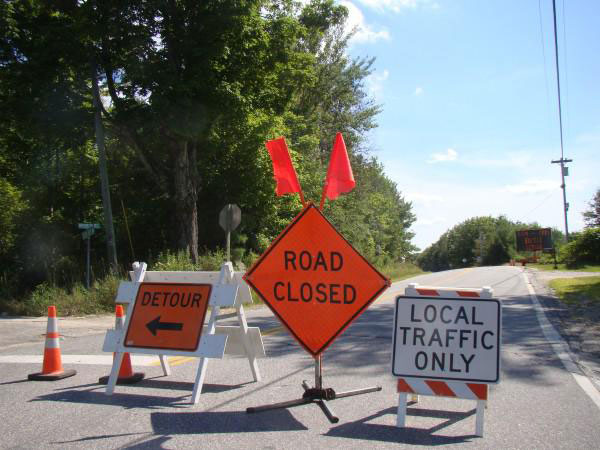
If the incident is only disruptive, a better option maybe to reroute traffic around the scene via another lane or by using a road shoulder or breakdown lane. Preplanning for these types of traffic control at target locations is still valuable, as they can map the appropriate locations for placement of “emergency scene ahead” signs, as well as the placement of traffic cones for merging traffic and other scene-safety variables.
The viability of a detour is also determined by its ability to accommodate not just passenger traffic, but larger vehicles, such as campers, construction vehicles, and tractor trailers. If your planned detour includes nonpaved and unimproved roads, low clearances, or hills with a slope greater than eight percent, not all traffic may be able to use it. Plan for staging and notifying incoming traffic further down-route to any limits with your roadway detours.
Implementation is the third component of a detour routing program. Tasks at this stage include documenting your detour routes, incorporating your detour program into your highway response SOGs, and implementing a training session to familiarize your responders with the detour program maps and associated activities.
Although there are sophisticated programs for rerouting traffic on the fly, most dispatchers and first responders do not have easy access to these tools, though smartphones and other small-footprint devices may improve this in the near future. For the time being, static mapping of the detours for your target roadways hazard areas provides a sufficient solution–there are several simplified ways to do this electronically. Ideally, combine these map documents with detour directions that are easily accessed and communicated during an emergency. Maps, along with their documented directions and notes of any roadway limits, will complement your scheduled trainings. Use these along with preplanning discussions to familiarize your responders with your jurisdiction’s roadway hazard areas and associated preincident detour plans.
When presenting training on your detour routing program, ensure that time is spent reminding responders that working a roadway incident is a major cause of responder death and injury; and that these deaths and injuries are often preventable. Where possible, predetermine and map appropriate locations that give traffic flaggers safe escape areas. Also, ensure that all flaggers have the proper safety gear, which includes reflective personal protective equipment, a flashlight, signage, and a working two-way radio.
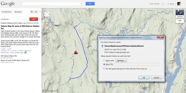
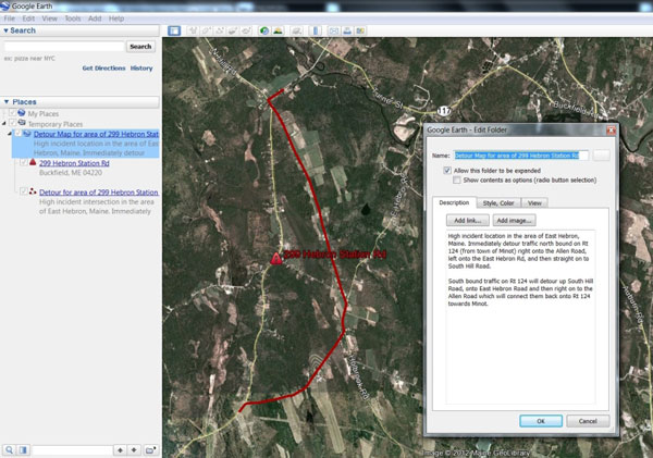
(2-3) Several no- and low-cost mapping programs can be used to create simplified static and electronic maps of your target roadway hazards. Examples include Google Maps, which is easily shared and also easy to save as a .kml file for viewing in Google Earth.
ADDITIONAL TIPS
Solicit responders and/or local citizens who have cartographic (mapping) skills and ask for their assistance with designing, reviewing, and compiling your roadway hazard and detour maps.
Use highway crash data and other incident statistical data available from your local police department and the National Fire Information Reporting System (NFIRS) to help target high- incident areas.
If using maps and predetermined directions from an online electronic mapping program, review to ensure the directions are correct and up-to-date. Also, work to keep the files current as new roads and growth patterns affect your response.
Coordinate mapping and implementation plans with your local department of transportation, fire and police units, and other town officials.
Share electronic mapping files and detour plans with your mutual aid departments. The quick implementation of a detour by a mutual-aid town ensures increased safety and will allow your own responders to attend to duties directly on scene.
**
Using a detour routing program to mitigate roadway hazards will ensure a higher level of safety and increased efficiencies with public service. Citizens, responders and all public personnel involved will appreciate the fact that your department is prepared to safely and efficiently insure that even during a major incident–they can get there from here.
Vicki Schmidt is a fire service Instructor and a geographical information specialist (GIS) for the state of Maine. She also serves on the Maine Fire Protection Services Commission and is a firefighter and training officer for the Buckfield Fire Department. Schmidt’s fire service activities also include Maine’s Fire & Life Safety Technical Advisory Group and coordinating the Western Maine Fire Attack School.
MORE VICKI SCHMIDT

