By RYAN GIFFORD
I started flying model helicopters because I thought they looked “cool”; this was before the advent of gyro-stabilized platforms, and I’d never before heard the word “quadcopter.” I gave up on it after about two years not because it wasn’t fun but because I ran out of money and time to repair my small 250s after every flight. Needless to say, I wasn’t an epic pilot.
What Does NFPA’s Drone Standard Mean for Your Fire Department?
Best Practices for Fire Service UAS
Do Fire Departments Need a Futures Command?
Fast forward a few years. You can now walk into a big box store and walk out with a fully global positioning system-stabilized, state-of-the-art flying camera platform for a very reasonable price. Unfortunately, walking into a store and coming out with a fully functioning aircraft that operates in the National Air Space (NAS) without so much as a test flight has led some fire and law departments to do just that.

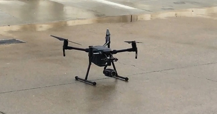
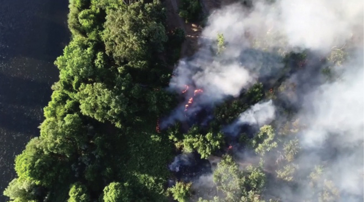
(1) This UAV with a zoom camera is a mainstay for overwater operations including payload delivery. (Photos courtesy of author.)
Creating Our Program
About six years ago, the Sacramento (CA) Metropolitan Fire District, where I am a member, started an unmanned aerial vehicle (UAV) program. However, the cost of technology and the requirements set forth for public agencies to fly in the NAS at that time were, understandably, more than what our budget could support. Fast forward a few more years: The price of technology has come down, the reliability of the aircraft has come up, and the Federal Aviation Administration (FAA) has hesitantly allowed public aircraft to exist in the fire service. However, many agencies that I talk to about their UAV programs are still in that same vacuum: “Yeah, we’ve got a drone and a guy who flies it sometimes”; this is NOT a public aircraft UAV program, and it’s certainly not the mentality public safety organizations need to foster. Some of the most important things I learned as we built our UAV program can be summarized in one sentence: Buy your aircraft last; talk to your neighbors first.
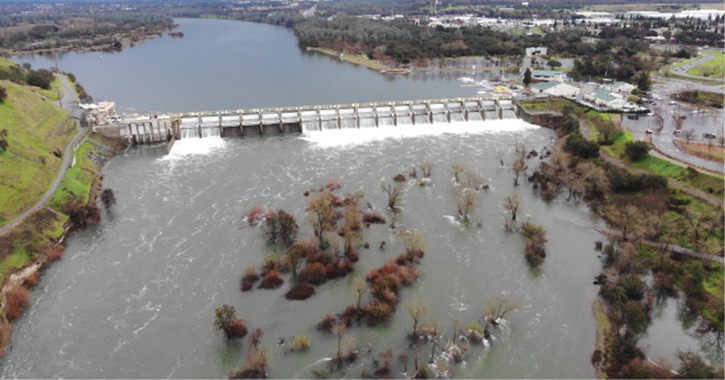
(2) Hazard planning flooded areas near the Nimbus Dam on the Sacramento River, Sacramento, California.
To address the first half of that sentence, the key to building a successful UAV program lies not in buying all the technology you can (even if you could afford it) but in understanding the mission you can fulfill for your agency that brings worth to the tool. Think about it this way: You’ve got a whole host of tools and options on your engine or truck. You certainly don’t use them all the time, but when you need the right tool for the right job, you pick it. And, more importantly, there are a bunch of tools that aren’t found on your truck because they just won’t ever get used, and they wouldn’t add value to your operation even if you did have them. UAVs are the same way. One of the quickest ways to sink a program is to have tools (i.e., UAVs) that won’t, don’t, or can’t get used in your normal operations and wouldn’t add value even if you did have them.
For example, my fire district has large areas of wildland urban interface in two distinct parts of our coverage area as well as along the river, so we wanted one particular company’s thermal imaging cameras (TICs) to chase down hot spots in the grass after those midafternoon incidents. Using this company’s thermal imaging, I argued, would reduce resource allocation during “mop-up” and give the members some rest before they head to the next job that afternoon. We can use it for everything, right? Well, yes and no. For instance, if you’re in grass fire season, the ground is already pretty warm, so much so that small areas of still smoldering fuels may blend into the background when viewed through a TIC from 150 feet or so. So, I started learning about things I’d never heard of, like thermography and Delta T. I discovered that, for the resolutions at which most aerial TICs on a quadcopter operate, you need to be about 20 feet away from those small hot spots to find them effectively. That’s not very efficient—or safe—with a quadcopter. We wanted the ability to locate hot spots on grass fires, but had I done more research on how the specific products I was looking at worked, I probably would have realized that spotting the telltale signs of a hot spot (small areas of smoke or creeping black) is best done from a higher and safer altitude using a visual lens camera and then confirming it from a lower altitude with a TIC. Not only is this more efficient, but it’s safer.
This realization probably would have taken me down the road to a slightly different product than that which we bought out of the gate. That said, we found other uses for the equipment we purchased that proved reliable and on which we continue to rely for training and other missions. However, it wasn’t the tool we’d have picked if I’d bought the equipment last and figured out the entire mission scope and need earlier in the equation. As we started to learn to look first and buy second, we also gained knowledge from other agencies that were creating UAV programs of their own.
This leads to the second part of the above sentence: Talk to your neighbors first. After we started putting considerable effort into inventing this “wheel,” we came in contact with other local agencies that had already figured out some of the mistakes we might have otherwise made. After introducing ourselves to one of the local law agencies, it invited us to a vendor event for a UAV company two days later. After attending the event, I learned that not only were there more equipment options than what I knew about, but there were also several agencies with which we shared borders that were actively trying to figure out the same things we were trying to figure out! As it turns out, talking with a couple of deputies and a few firefighters in a parking lot is a great way to jump-start your UAV program.
Since we all had the same objective, I suggested we meet and talk about it in a more professional setting. So, we planned a meeting with some county agencies that were also looking to create a UAV program. Then, I started getting e-mails stating things such as, “Hey, these guys are also looking at a UAV program; have you invited them?” It seemed like everyone I spoke with knew another agency that had similar needs. A couple of quarterly meetings later, our regional group encompassed about 28 fire and law agencies from across four counties.
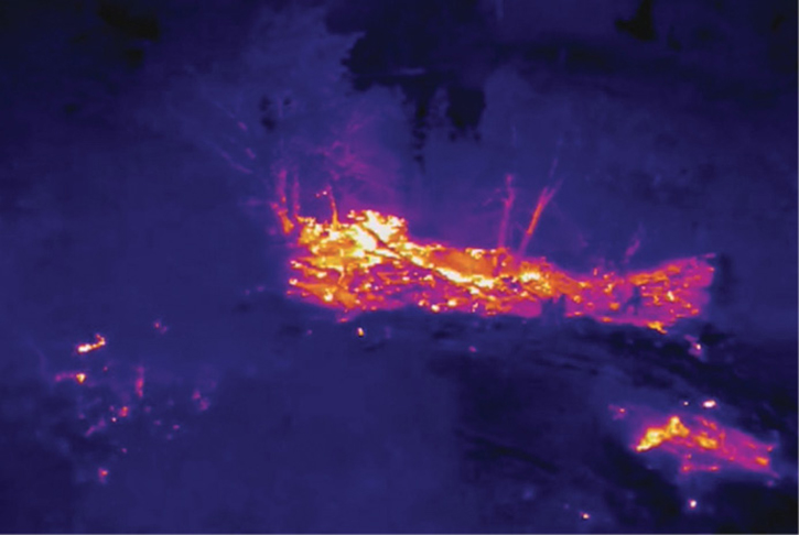
(3) Advanced scouting over a vegetation fire in deep undergrowth along the Sacramento River.
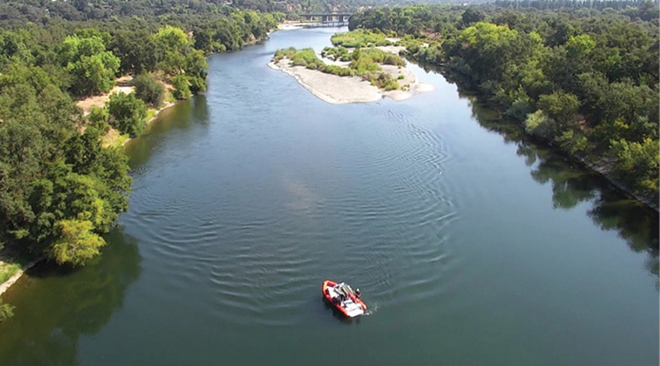
(4) A crew is monitoring advanced water rescue operations near the Arden Ponds in Sacramento, California.
(5) Filming engineer training for posttraining review, Citrus Heights, California.
Another benefit from talking to your “neighbors” is that, besides learning from their mistakes, forming a “working group” with regional agencies will catch the attention of the regions and entities beyond the regions. Not only did we secure Urban Areas Security Initiative funding to attend conferences, but we are now setting up a regional training site using new National Institute of Standards and Technology (NIST) UAV props (made possible through a group member’s contact at NIST). Another group member was part of the National Fire Protection Association 2400, Standard for Small Unmanned Aircraft Systems (sUAS) Used for Public Safety Operations, author’s group, and another group member involved in manned public safety aircraft had some great ideas on improving manned/unmanned operations in the region. The list goes on, but the theme is the same: Talk to your neighbors!
Getting Started
Following are the four categories that you need to address before you move forward with a UAV program:
Identification. Here, we defined mission scope and prioritized needs while determining UAV types for use within our program.
First, develop your mission profiles and ask what challenges they provide. Be realistic, but also look at the profile in the long range. What do you want to accomplish with your program when it’s all built out? This takes time and truly thoughtful introspection; it will take a lot of discussion with your bosses and line personnel. Find out what’s lacking and how you might fulfill the need. No program is perfect, and no tool is universal, so look at the wide range of mission profiles you want to engage and figure out what challenges these profiles provide.
For example, saying, “We lack the ability to see all sides of a large grass fire, and the verbal intel we get from the units in the field is sometimes inconsistent and without geographic markers to provide a clear picture to the incident commander, leading to confusion” and “We lack plot plans or preplans that provide good views of our target hazards” are challenges you should prioritize; then create a solution statement for each.
Second, create a list. Do you respond to river calls, mountain search and rescue, and commercial fires; run roof reports; or get involved in public education? If so, these go on your list. Again, no tool is universal, so figure out the problem you most want to fix and work on that one first. Decide how a UAV can improve the problem, but don’t force the issue; UAVs can’t fix every problem. For each “challenge,” look at ways a UAV might help. Don’t limit yourself to any particular piece of equipment. Figure out the solution statement to the problem, not the tool you think will fix the problem. Do you need to provide visual situational awareness over a large grass fire for the duration of the event? Quadcopters are probably not the best tool for that. Rather, your solution statement could read, “A device that can carry a visible light camera and stay aloft for a long time over a wide range.” You need a solution statement for each challenge before you move to the next step.
Third, once you’ve defined the solution statement for each challenge on your list (and figured out which ones a UAV might not fix), define what type of UAV allows this fix to occur. As previously stated, with a solution statement in hand, you can now research which options are available to you. This takes some time and no small amount of effort, but it’s essential to being successful. Altitude, range, sensor type, automation, loiter times, and cost.
Fourth, once you’ve figured out what UAV types will help you through each solution statement, evaluate that list and find any overlap. In my few experiences with this process, there’s always some level of overlap. However, this makes sense given that many of our public safety missions have commonalities. There will probably be one, two, or several outliers as well.
Last, weigh all of this against your priorities list. Overlapped UAV types will get you the best equipment for your investment; multiple mission profiles accomplished by a single UAV type mean you’re getting the most utility from the tool you’ve purchased. Of course, if your equipment overlap happens at the lowest priority levels on your list, you’ve got a decision to make: Do you buy a unitasker that accomplishes a very important mission, or do you buy a multitasker that accomplishes many less important missions? I don’t have an answer for either question, but my fire district went with the multitasker, mostly because our priority list didn’t have a huge stand-out pick, and we wanted to get the most bang for our buck and the best positive exposure for our program. However, that was our choice; yours may be very different.
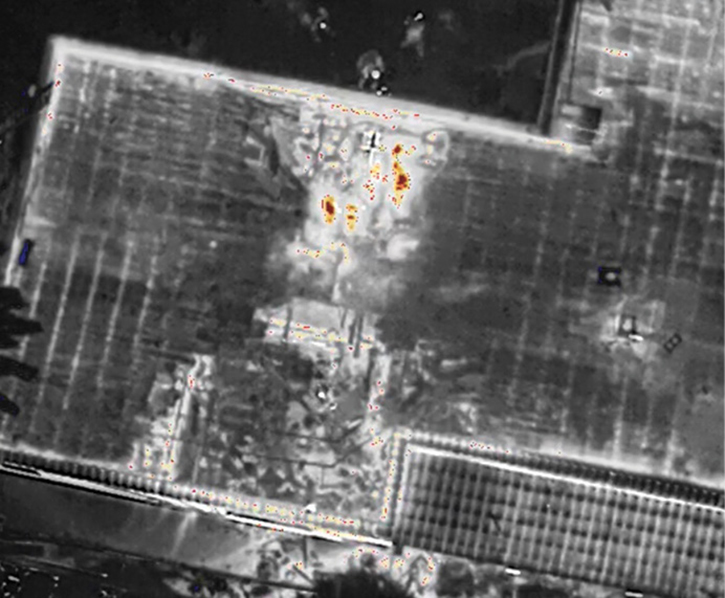
(6) Thermal imaging view streamed to command to assist with overhaul on a large residential occupancy, Rio Linda, California.
Now that was a lot of work! But we’re not even halfway done; we’re still not in a position to buy aircraft yet. We still need to draft out a training program; use, media, and dispatch policies; and mutual-aid requests or transdiscipline use (i.e., fire and law agencies working together). We wanted to complete every step to help figure out what equipment we wanted to buy because we were at the point where we had to show something tangible to the administration, the board, and the public to garner positive press. Why is this press needed? Because they may ask you to fly it, or they may also say, “Very cool! Make it work and show me its worth!” If you are not prepared to do this, you are in a bind.
Although it may well take many months or possibly years to get your program completely laid out (depending on the level of funding available and the comfort of your administration) and, in that time, newer, more capable versions of your desired aircraft are released, you still must be in a legal position to fly within the NAS; “Because we’re the fire department” does not impress the FAA.
At this point, all you’ve done is decide whether you should build a UAV program. If you’ve defined and prioritized your needs, found equipment that meets those needs and your budget, and decided to move forward, the next step is to define how to move forward. (Did I mention that buying the equipment comes last?)
Some people might say that this is the time (if not before) to go get approval from your city manager or your board. I’m not saying that’s incorrect, but you really have nothing to show them yet. I suppose it depends on your relationship with them. If they trust you and are generally supportive of your programs, this might be a good time to bring forward your thoughts. However, you still don’t necessarily have all the pieces in place to make someone who doesn’t understand what the letters “UAV” mean comfortable with making a decision. Your program is better served by creating a more complete outline before you approach the board with it.
Authorization. Arguably, one of the most important choices you must make when forming your UAV program is the type of authorization process. The FAA allows two authorizations: Commercial (FAR Part 107) and a Public Aircraft Certificate of Authorization (COA). There are valid arguments for and against both, but be mindful: You need both. If you’re not familiar with them, following is the most basic breakdown of each.
Part 107. This is designed to create a (very) basic educational requirement and to register individuals who want to collect money from flying UAVs. Included is a written test that, based on its high difficulty, you absolutely must study for to pass. It costs $150 per pilot to take the test and does not include a retest if you don’t pass it the first time. The certificate is good for two years, after which time you must take the test again, costing another $150. Part 107 also includes a no flight testing requirement (which is subject to change). Also, with the advent of the FAA’s Low Altitude Authorization and Notification Capacity (LAANC), Part 107-authorized pilots now have access to some flight-restricted areas around larger airports. Not all airports participate in LAANC.
In our area, all four major airports have restricted airspace that makes the county into “Swiss cheese.” Only two of those airports participate in LAANC, which means you don’t have automatic authorization to fly around in those areas. To gain access for emergency flights or to fly at night under Part 107, you must file a waiver with the FAA for each pilot. Part 107 wasn’t written for emergency responders, but the FAA likes it because it shows a measureable level of basic competency in understanding the rules it wants enforced.
Part 107 also places responsibility on one individual if there’s an accident or incident because it’s the pilot—not the agency—who is certified to fly and to understand and follow the rules. The waivers and LAANC aside, the Part 107 system is used by many agencies because there’s very little internal work needed to get pilots certified and there’s a legal license to point to for validating the pilot’s “legal status.” The folks you want to fly must figure out how to get their 107 certifications. So, if you don’t have non-LAANC airports around you and you don’t mind hammering out waiver requests, Part 107 works pretty well. And there’s less paperwork to file!
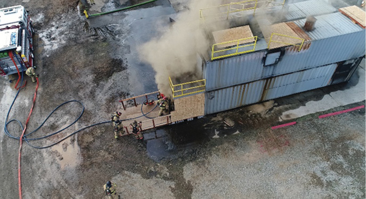
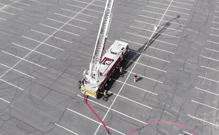
(7) UAV pilot training above a live burn prop, Florin, California.
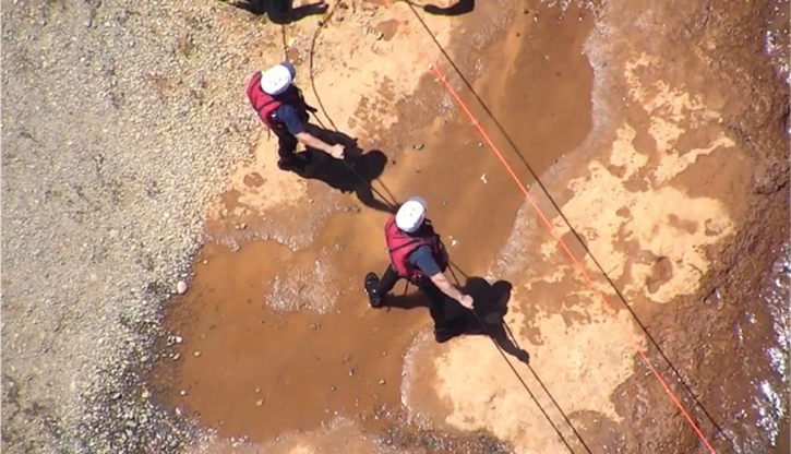
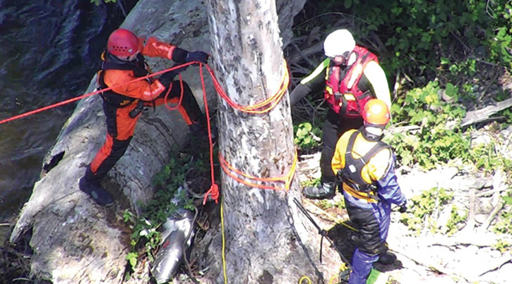
(8) Assisting with technical water rescue training near Arden Ponds, Arden, California.
However, what if you’re a larger agency and have, say, 40 pilots you want to certify? That’s $6,000 every two years out of your budget just to keep your pilots certified. And you’re still going to have to set up internal policies and protocols, all of which will exceed the minimums in Part 107. No board or city manager anywhere is just going to say, “Go fly”; they will all want to know how you intend to keep people safe and be effective with your equipment while maintaining the delicate political balances that come with a program like this.
Certificate of Authorization (COA). This is an agreement between your agency and the FAA that essentially says, “We understand you need this tool to help the public, we trust you, so write the policies and training requirements that make sense to you and follow these basic rules.” Although there are hoops to jump through, that’s an awful lot of trust! The FAA has streamlined the process to obtain what’s known as a Blanket COA. What used to take months can now be accomplished in as little as a week (but probably won’t be). Essentially, your agency completes what’s referred to as a Public Declaration Letter (PDL), which states who you are and that you are responsible to a legal subdivision of the state in which you operate. So, if you’re a city department, you work for a city (a political subdivision of a county, which is a political subdivision of the state), and you’d need the city attorney to sign the PDL. If you’re a county department, it’s the county counsel that signs it—your agency cannot sign it! This means not your chief, human resources chief, or safety chief. The intent of the letter is to prove to the FAA that your department is an actual emergency services agency; it wants a legal counselor that works for the political subdivision above you to agree to that. Confused? If so, call the FAA’s legal department and ask for clarification. The lawyers will be nice and helpful. I’ve called them and spoken to their lawyers several times, and I’m always told to call back anytime because they genuinely want you to do things properly, be safe, and be legal.
After the appropriate legal counsel signs the PDL and submits it for approval, you’ll be granted access to the FAA COA Application Process (CAPS) Web site. CAPS is the FAA’s one-stop shop for COAs. Here, you’ll upload your airworthiness statements that you create for your aircraft, complete the COA application, and make your monthly reports to the FAA about all your flights under the COA.
A COA is a big deal. Essentially, the FAA is granting you the privilege of self-certifying your pilots and deciding what minimum training your agency needs to be safe and effective—as long as you meet their minimum requirements, which are quite low. It also grants your agency the privilege of flying at night and over people (in certain cases). (Notice I said your agency and not your pilots?) That’s because a COA authorizes a public agency, not a specific pilot. This means you can groom as many pilots as you need in the manner and methods that best fit your operation. It also means, should there be an incident, the FAA will talk to the program manager about the program as well as the incident. COAs give you a lot of freedom, but they ask for something in return. For each flight under a COA, you need to file a Notice to Airman (NOTAM) with the FAA. This usually needs to occur 24 to 72 hours before the flight (there are exceptions for emergency missions). The NOTAM tells other pilots in the area that you’re flying there and may be a hazard, even though you’re following the basic minimum safety standards set forth for COA and Part 107 pilots. This means you can’t just train whenever you want.
Although NOTAMs are easy to file online, there is another layer of planning required to fly that’s not required under Part 107. Additionally, you’re required to file a report each month with the FAA about all the flights made under your COA as well as any incidents that occurred through CAPS. It’s not hard, but it’s another layer for the program manager to work through. Last, you cannot make money or use for marketing any video or picture from a COA flight. That means you can’t use UAV video from that commercial or vegetation fire or river rescue for a recruitment video if it was captured under a COA flight.
So, there are some significant restrictions to using a COA, but the COA also gives you a level of access to restricted airspace that Part 107 does not, at least without filing paperwork well in advance for each pilot within the program. In our area, this means making a simple phone call to a functional office in Washington, DC, that’s open and responsive 24 hours a day to fly within restricted airspace. And, through an extended process called a “Jurisdictional COA,” the FAA can grant you continual access to those flight-restricted areas without so much as a phone call. Just file the online NOTAM—which takes less than two minutes—and you are on your way.
The FAA isn’t necessarily wild about granting COAs because it puts a lot of responsibility on a fire or law agency to create, implement, and maintain a program’s safety and functional limits, but it understands the benefits to the agency and, so, it supports it. However, this level of trust means that your agency is “on the hook” to maintain the high standards of the program and for everything that goes on within it.
After finding out how all this works (and it’s changing), the question then becomes, how do these programs best benefit your agency? As stated earlier, any well-constructed UAV program should function under both a COA and FAR Part 107. The COA gives flexibility to train larger numbers of pilots for less monetary cost, allows you to concentrate the training areas to benefit your program, grants more access to restricted airspace than Part 107 (in some cases), and allows for night flights and flights over populations (in some cases). Part 107 allows you to train without filing a NOTAM in some airspaces and to use your UAVs in situations that might be considered commercial in nature.
The combination of your agency operating under a COA, with a “smattering” of Part 107 pilots, brings the best of both worlds. Of course, that does mean managing both sides of that equation within your program but, for our agency, the benefits have outweighed the negatives.
Policies. Ok, so, you’re ready to start this program? Not quite. Now that you know what aircraft capabilities you want to buy based on mission profile and agency need, and you know what type of authorization you want from the FAA, outline your training and use policies. It’s important to start this step knowing that it will probably continually change as you move forward with your program because, as you talk to more neighbors and learn more about the tools available to your program, you’ll need to construct outlines on how to use these tools safely and effectively.
Also, the use of UAVs in public safety continues to evolve in terms of equipment and regulations. The policies you construct today may very well need amending before you fly your first live mission; ours certainly did. There are many options here; your agency, region, or state will have its own specific needs that you’ll need to address. That said, following is a minimal list of items you’ll need to address:
- Initial training qualifications and requirements including documentation that your program meets FAA minimum requirements.
- Training, preflight inspections and checks, flight logging, video capture documentation, and process policies.
- Safety, security, privacy, and maintenance policies.
- Use and deployment policies.
- Accident reporting and mitigation policies.
- Mutual-/automatic-aid policies.
- Recurrent training policies.
As with everything else, talk to your neighbors first. It’s possible they’ve started this process or may be able to give you additional information or ideas you hadn’t yet thought of. Additionally, don’t operate within your own vacuum. Engage with your training division and figure out what tools it already has in place to help create, review, and validate the policies that you want to build.
(9) Thermal imaging views streamed to command help them decide where to land fire crews off of rescue boats for a fire on an island in the middle of the Sacramento River at night in Sacramento, California.
(10) Coordinated search training with a rescue boat company over the Sacramento River, Sacramento, California.
Obviously, there’s a lot going on here, but you might be surprised at how many of these policies already exist in your department. Some might just need a tweak to make them work for you. Regardless, use your resources—internal and external—to help you through this process.
Deployment. We’re getting closer! The last piece you need to address before you start this process is a deployment model—that is, how are you planning to get an aircraft and a qualified pilot in the same place at the same time at the scene at which you want to operate, and how are you going to do it within a time frame where the UAV is relevant to the operation?
For planned-need events (i.e., preplanning or public education events), this is a simple matter of scheduling. However, for emergency scenes, this becomes much more complicated. Following are some options that fire and law enforcement departments currently use:
Centralized Model. Here, the UAVs are in a central location such as a dedicated delivery vehicle or at headquarters. On request, a pilot heads to this location to pick up the UAVs or the delivery vehicle and then heads to the scene.
- Pros: Requires fewer UAVs than other models and provides ease of access for maintenance of UAVs because they are centrally located. Works well for geographically small departments.
- Cons: Longer “reflex times” to get the UAV airborne than with other models. Requires coordinating the movement of a pilot (or other currier) to the central location when the UAV is needed. Poorly suited to geographically large departments. (The reflex time is defined as beginning once the request for a UAV to fly is made and ending when the UAV is lifting off to do its job, legally and safely.)
Decentralized Model. In this model, UAVs are located with the pilots, spread throughout the geographic range of the department. On request or need, the pilot takes out the UAV and initiates the flight. A word of caution here: Although this model may seem perfectly fitted to training your battalion chiefs (BCs) to be pilots and then putting a UAV on their apparatus, I would suggest against it. Flying a UAV requires focus and attention. Pulling the BC’s attention into the UAV flight screen takes him away from running the call and making the important command decisions that he’s there to perform. Although agencies have implemented BCs as pilots successfully, it’s not something that would work in our department, and I’d caution you to think long and hard about the impacts of using BCs as pilots before you decide to move in that direction.
- Pros: Very fast reflex times to get the UAV airborne. Appropriate for many different geographically sized departments. As the UAVs are housed with the pilots, maintenance and upkeep are easier to perform.
- Cons: Requires more UAVs than other models. Requires pilots to keep the UAVs with them or, if the UAV stays with an engine or a truck, this model requires a qualified pilot to be assigned to that rig every day. This model requires important decision points be established: Does the arriving engine fulfil its roll within the standard operating guideline (SOG) to whatever call type it’s dispatched, or does it fly the UAV? Who decides this?
Remote Node Model. Here, the UAVs are kept in several specific locations (nodes) within the geographic area such as on a BC’s apparatus or individual rigs spread throughout the agency, and the pilots are spread throughout the department separately.
- Pros: Allows a balance of reflex time to launch the UAV vs. scene requirements. Also allows UAVs to be nearer the potential incident locations throughout a larger geographic department and for pilots to be spread around the department and come to the scene to fly as needed. This model also gives the incident commander some latitude on using a qualified pilot from a unit already on scene to fly if it is more relevant to put the UAV into service at that point than using the pilot as part of the SOG. Or, it allows the SOG to run as normal while an additional unit carrying a pilot responds to the scene to fly.
- Cons: Because the UAVs are not housed with the pilots, implement a process to ensure maintenance and upkeep of the UAVs. Also, you need to develop a system to request a pilot to the scene if one is not already assigned to the call and available.
Although there are other deployment models or variations of the ones presented above, you must consider the reflex time to get the UAV airborne. Considering the time frame when gathering situational awareness is most critical during an emergency, our goal is a 15-minute reflex time—that is, from the time it’s determined that a UAV is needed for a call, the aircraft is in the air no more than 15 minutes later. Although some models decrease reflex time immensely, this usually comes at a significant monetary cost. You need a balance and, depending on your department’s size and layout, any, all, or none of these deployment models may meet the reflex time that you choose while being financially viable.
Taking the Final Steps
So, it’s finally time to present your findings and recommendations to the administration and then the board or city for approval! You’ve made a calculated needs assessment for your department and identified UAVs that can meet those needs within your budget. You’ve also determined which authorization model is the best fit for your department and your UAV program’s mission and scope. You’ve outlined several policies that will help guide training, safety, privacy, maintenance, and documentation. Last, you’ve determined which deployment model gets your UAVs to the scene in a time frame that makes a difference. Armed with all this, you’re ready to make an informed presentation and answer the inevitable questions that will arise. After you get the approval to start the program, the real fun begins.
Based on your identification of need, you can now budget to purchase your first UAVs. At the same time, start the process for the authorization types you’re going to pursue. Begin filling in the details on your program policies and start structuring your equipment based on your deployment model.
Finally, recruit interested pilot candidates and put them to work on the ground floor of this project. They’ll be motivated to see it move forward and will become the subject matter experts on your UAV program while learning how to fly the missions for which the program is designed. They’ll also be an excellent resource as you begin to expand your program with grant funding and regional cooperation in the future. It is truly a collaborative effort. At our department, none of this would have been possible without the support of the administration and the board of directors.
RYAN GIFFORD is a captain/paramedic for the Sacramento (CA) Metropolitan Fire District (Metro Fire). He is also Metro Fire’s unmanned aerial vehicle program manager, a district computer-aided dispatch coordinator, and an operation safety officer for the C-Shift. Gifford is also a medical team manager for the FEMA urban search and rescue team from Sacramento, CA-TF7.

